You are here: Home > Network List > IU - Global Seismograph Network (GSN - IRIS/USGS) Stations List
> Station KEV Kevo, Finland > Earthquake Result Viewer
KEV Kevo, Finland - Earthquake Result Viewer
| Earthquake location: |
Komandorskiye Ostrova Region |
| Earthquake latitude/longitude: |
54.8/164.8 |
| Earthquake time(UTC): |
2018/12/20 (354) 17:01:56 GMT |
| Earthquake Depth: |
33 km |
| Earthquake Magnitude: |
7.3 Mi |
| Earthquake Catalog/Contributor: |
NEIC PDE/pt |
|
| Network: |
IU Global Seismograph Network (GSN - IRIS/USGS) |
| Station: |
KEV Kevo, Finland |
| Lat/Lon: |
69.76 N/27.00 E |
| Elevation: |
100 m |
|
| Distance: |
52.0 deg |
| Az: |
342.749 deg |
| Baz: |
29.52 deg |
| Ray Param: |
0.06697799 |
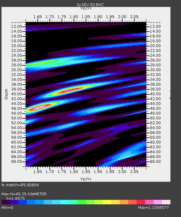
| Estimated Moho Depth: |
45.25 km |
| Estimated Crust Vp/Vs: |
1.66 |
| Assumed Crust Vp: |
6.622 km/s |
| Estimated Crust Vs: |
3.995 km/s |
| Estimated Crust Poisson's Ratio: |
0.21 |
|
| Radial Match: |
95.80654 % |
| Radial Bump: |
400 |
| Transverse Match: |
82.57102 % |
| Transverse Bump: |
400 |
| SOD ConfigId: |
3201911 |
| Insert Time: |
2019-01-03 17:14:28.956 +0000 |
| GWidth: |
2.5 |
| Max Bumps: |
400 |
| Tol: |
0.001 |
|
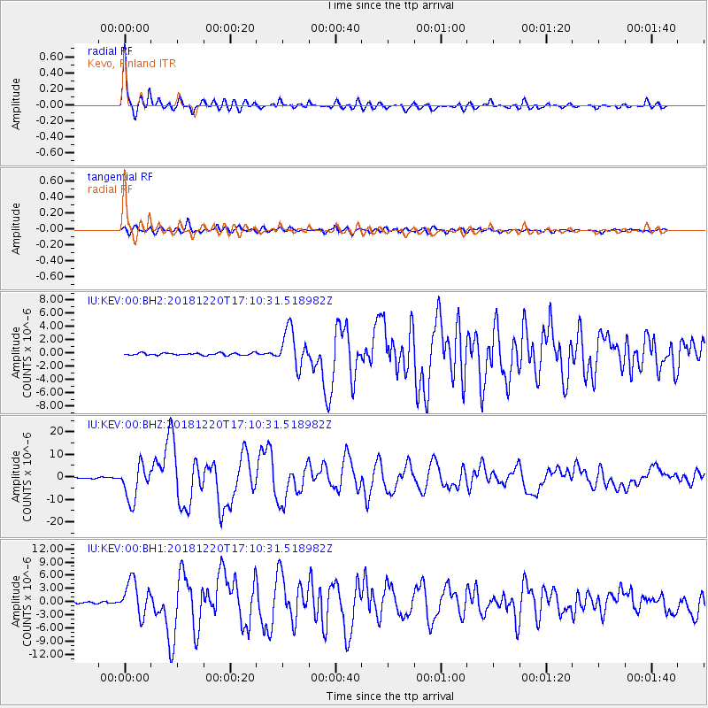
Signal To Noise
| Channel | StoN | STA | LTA |
| IU:KEV:00:BHZ:20181220T17:10:31.518982Z | 29.337168 | 7.90816E-6 | 2.6956113E-7 |
| IU:KEV:00:BH1:20181220T17:10:31.518982Z | 23.931381 | 3.92608E-6 | 1.6405572E-7 |
| IU:KEV:00:BH2:20181220T17:10:31.518982Z | 18.039629 | 2.837761E-6 | 1.5730706E-7 |
| Arrivals |
| Ps | 4.8 SECOND |
| PpPs | 17 SECOND |
| PsPs/PpSs | 22 SECOND |


