You are here: Home > Network List > US - United States National Seismic Network Stations List
> Station EGMT Eagleton, Montana, USA > Earthquake Result Viewer
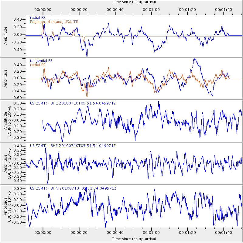
EGMT Eagleton, Montana, USA - Earthquake Result Viewer
*The percent match for this event was below the threshold and hence no stack was calculated.
| Earthquake location: |
Mariana Islands |
| Earthquake latitude/longitude: |
14.0/145.0 |
| Earthquake time(UTC): |
2010/07/10 (191) 05:39:43 GMT |
| Earthquake Depth: |
136 km |
| Earthquake Magnitude: |
5.6 MB, 5.6 MW, 5.5 MW |
| Earthquake Catalog/Contributor: |
WHDF/NEIC |
|
| Network: |
US United States National Seismic Network |
| Station: |
EGMT Eagleton, Montana, USA |
| Lat/Lon: |
48.02 N/109.75 W |
| Elevation: |
1055 m |
|
| Distance: |
89.6 deg |
| Az: |
40.374 deg |
| Baz: |
290.507 deg |
| Ray Param: |
$rayparam |
*The percent match for this event was below the threshold and hence was not used in the summary stack. |
|
| Radial Match: |
27.872665 % |
| Radial Bump: |
400 |
| Transverse Match: |
38.729897 % |
| Transverse Bump: |
400 |
| SOD ConfigId: |
319893 |
| Insert Time: |
2011-01-05 01:22:04.633 +0000 |
| GWidth: |
2.5 |
| Max Bumps: |
400 |
| Tol: |
0.001 |
|
Signal To Noise
| Channel | StoN | STA | LTA |
| US:EGMT: :BHZ:20100710T05:51:54.049971Z | 3.2726777 | 2.1770543E-7 | 6.652211E-8 |
| US:EGMT: :BHN:20100710T05:51:54.049971Z | 0.64885724 | 1.0975064E-7 | 1.691445E-7 |
| US:EGMT: :BHE:20100710T05:51:54.049971Z | 0.99631625 | 1.2974733E-7 | 1.3022706E-7 |
| Arrivals |
| Ps | |
| PpPs | |
| PsPs/PpSs | |


