You are here: Home > Network List > UW - Pacific Northwest Regional Seismic Network Stations List
> Station ETW Entiat, WA, USA > Earthquake Result Viewer
ETW Entiat, WA, USA - Earthquake Result Viewer
| Earthquake location: |
Hokkaido, Japan Region |
| Earthquake latitude/longitude: |
41.1/142.8 |
| Earthquake time(UTC): |
2023/08/11 (223) 00:14:32 GMT |
| Earthquake Depth: |
30 km |
| Earthquake Magnitude: |
5.9 mww |
| Earthquake Catalog/Contributor: |
NEIC PDE/us |
|
| Network: |
UW Pacific Northwest Regional Seismic Network |
| Station: |
ETW Entiat, WA, USA |
| Lat/Lon: |
47.60 N/120.33 W |
| Elevation: |
1469 m |
|
| Distance: |
65.1 deg |
| Az: |
47.817 deg |
| Baz: |
304.181 deg |
| Ray Param: |
0.058477525 |
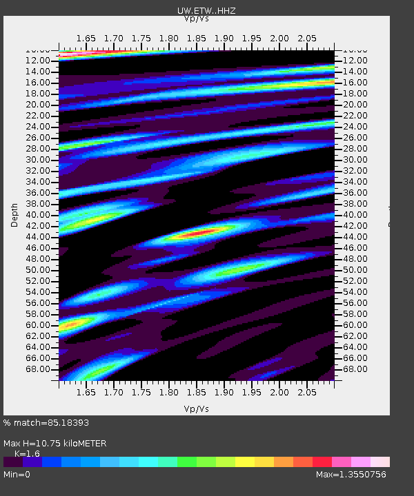
| Estimated Moho Depth: |
10.75 km |
| Estimated Crust Vp/Vs: |
1.60 |
| Assumed Crust Vp: |
6.597 km/s |
| Estimated Crust Vs: |
4.123 km/s |
| Estimated Crust Poisson's Ratio: |
0.18 |
|
| Radial Match: |
85.18393 % |
| Radial Bump: |
400 |
| Transverse Match: |
78.33332 % |
| Transverse Bump: |
400 |
| SOD ConfigId: |
31937991 |
| Insert Time: |
2023-08-25 00:52:48.703 +0000 |
| GWidth: |
2.5 |
| Max Bumps: |
400 |
| Tol: |
0.001 |
|

Signal To Noise
| Channel | StoN | STA | LTA |
| UW:ETW: :HHZ:20230811T00:24:39.560023Z | 3.6669827 | 2.5238378E-7 | 6.882601E-8 |
| UW:ETW: :HHN:20230811T00:24:39.560023Z | 1.5044949 | 1.2056742E-7 | 8.013814E-8 |
| UW:ETW: :HHE:20230811T00:24:39.560023Z | 1.6408496 | 1.3660214E-7 | 8.325086E-8 |
| Arrivals |
| Ps | 1.0 SECOND |
| PpPs | 4.0 SECOND |
| PsPs/PpSs | 5.1 SECOND |


