You are here: Home > Network List > UW - Pacific Northwest Regional Seismic Network Stations List
> Station PASS Maple Falls, WA, USA > Earthquake Result Viewer
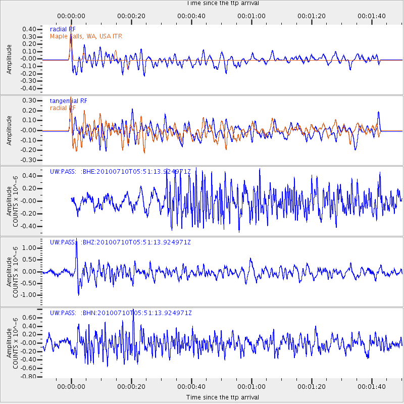
PASS Maple Falls, WA, USA - Earthquake Result Viewer
*The percent match for this event was below the threshold and hence no stack was calculated.
| Earthquake location: |
Mariana Islands |
| Earthquake latitude/longitude: |
14.0/145.0 |
| Earthquake time(UTC): |
2010/07/10 (191) 05:39:43 GMT |
| Earthquake Depth: |
136 km |
| Earthquake Magnitude: |
5.6 MB, 5.6 MW, 5.5 MW |
| Earthquake Catalog/Contributor: |
WHDF/NEIC |
|
| Network: |
UW Pacific Northwest Regional Seismic Network |
| Station: |
PASS Maple Falls, WA, USA |
| Lat/Lon: |
49.00 N/122.09 W |
| Elevation: |
174 m |
|
| Distance: |
81.4 deg |
| Az: |
41.694 deg |
| Baz: |
281.385 deg |
| Ray Param: |
$rayparam |
*The percent match for this event was below the threshold and hence was not used in the summary stack. |
|
| Radial Match: |
60.316475 % |
| Radial Bump: |
400 |
| Transverse Match: |
57.763683 % |
| Transverse Bump: |
400 |
| SOD ConfigId: |
319893 |
| Insert Time: |
2011-01-05 01:23:37.890 +0000 |
| GWidth: |
2.5 |
| Max Bumps: |
400 |
| Tol: |
0.001 |
|
Signal To Noise
| Channel | StoN | STA | LTA |
| UW:PASS: :BHZ:20100710T05:51:13.924971Z | 6.8078637 | 4.6716835E-7 | 6.862187E-8 |
| UW:PASS: :BHN:20100710T05:51:13.924971Z | 2.603188 | 2.0076868E-7 | 7.7124156E-8 |
| UW:PASS: :BHE:20100710T05:51:13.924971Z | 2.5348063 | 2.2693582E-7 | 8.952788E-8 |
| Arrivals |
| Ps | |
| PpPs | |
| PsPs/PpSs | |


