You are here: Home > Network List > UW - Pacific Northwest Regional Seismic Network Stations List
> Station RER Emerald Ridge, Mount Rainier, WA, USA > Earthquake Result Viewer
RER Emerald Ridge, Mount Rainier, WA, USA - Earthquake Result Viewer
| Earthquake location: |
Hokkaido, Japan Region |
| Earthquake latitude/longitude: |
41.1/142.8 |
| Earthquake time(UTC): |
2023/08/11 (223) 00:14:32 GMT |
| Earthquake Depth: |
30 km |
| Earthquake Magnitude: |
5.9 mww |
| Earthquake Catalog/Contributor: |
NEIC PDE/us |
|
| Network: |
UW Pacific Northwest Regional Seismic Network |
| Station: |
RER Emerald Ridge, Mount Rainier, WA, USA |
| Lat/Lon: |
46.82 N/121.84 W |
| Elevation: |
1751 m |
|
| Distance: |
64.6 deg |
| Az: |
49.172 deg |
| Baz: |
303.652 deg |
| Ray Param: |
0.058745965 |
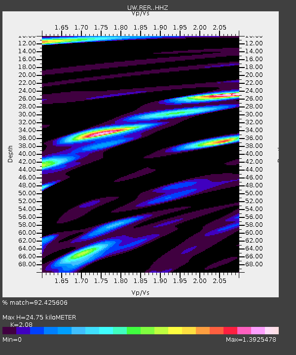
| Estimated Moho Depth: |
24.75 km |
| Estimated Crust Vp/Vs: |
2.08 |
| Assumed Crust Vp: |
6.597 km/s |
| Estimated Crust Vs: |
3.172 km/s |
| Estimated Crust Poisson's Ratio: |
0.35 |
|
| Radial Match: |
92.425606 % |
| Radial Bump: |
400 |
| Transverse Match: |
73.312386 % |
| Transverse Bump: |
400 |
| SOD ConfigId: |
31937991 |
| Insert Time: |
2023-08-25 00:54:01.789 +0000 |
| GWidth: |
2.5 |
| Max Bumps: |
400 |
| Tol: |
0.001 |
|

Signal To Noise
| Channel | StoN | STA | LTA |
| UW:RER: :HHZ:20230811T00:24:36.860011Z | 3.1657083 | 2.3385988E-7 | 7.387284E-8 |
| UW:RER: :HHN:20230811T00:24:36.860011Z | 2.1068063 | 1.5846214E-7 | 7.521438E-8 |
| UW:RER: :HHE:20230811T00:24:36.860011Z | 1.839139 | 1.6409518E-7 | 8.922392E-8 |
| Arrivals |
| Ps | 4.2 SECOND |
| PpPs | 11 SECOND |
| PsPs/PpSs | 15 SECOND |


