You are here: Home > Network List > NM - Cooperative New Madrid Seismic Network Stations List
> Station SIUC Carbondale, IL > Earthquake Result Viewer
SIUC Carbondale, IL - Earthquake Result Viewer
| Earthquake location: |
Komandorskiye Ostrova Region |
| Earthquake latitude/longitude: |
54.8/164.8 |
| Earthquake time(UTC): |
2018/12/20 (354) 17:01:56 GMT |
| Earthquake Depth: |
33 km |
| Earthquake Magnitude: |
7.3 Mi |
| Earthquake Catalog/Contributor: |
NEIC PDE/pt |
|
| Network: |
NM Cooperative New Madrid Seismic Network |
| Station: |
SIUC Carbondale, IL |
| Lat/Lon: |
37.71 N/89.22 W |
| Elevation: |
120 m |
|
| Distance: |
68.2 deg |
| Az: |
55.19 deg |
| Baz: |
323.22 deg |
| Ray Param: |
0.056389123 |
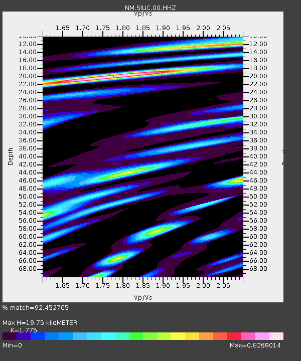
| Estimated Moho Depth: |
19.75 km |
| Estimated Crust Vp/Vs: |
1.77 |
| Assumed Crust Vp: |
6.444 km/s |
| Estimated Crust Vs: |
3.63 km/s |
| Estimated Crust Poisson's Ratio: |
0.27 |
|
| Radial Match: |
92.452705 % |
| Radial Bump: |
382 |
| Transverse Match: |
75.27809 % |
| Transverse Bump: |
400 |
| SOD ConfigId: |
3201911 |
| Insert Time: |
2019-01-03 17:16:03.679 +0000 |
| GWidth: |
2.5 |
| Max Bumps: |
400 |
| Tol: |
0.001 |
|

Signal To Noise
| Channel | StoN | STA | LTA |
| NM:SIUC:00:HHZ:20181220T17:12:22.440002Z | 3.9706707 | 4.34594E-6 | 1.0945103E-6 |
| NM:SIUC:00:HHN:20181220T17:12:22.440002Z | 2.4354453 | 2.1008527E-6 | 8.626154E-7 |
| NM:SIUC:00:HHE:20181220T17:12:22.440002Z | 1.1347251 | 1.0395704E-6 | 9.1614294E-7 |
| Arrivals |
| Ps | 2.5 SECOND |
| PpPs | 8.2 SECOND |
| PsPs/PpSs | 11 SECOND |


