You are here: Home > Network List > AK - Alaska Regional Network Stations List
> Station F15K North Star Ditch, AK, USA > Earthquake Result Viewer
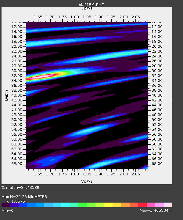
F15K North Star Ditch, AK, USA - Earthquake Result Viewer
| Earthquake location: |
South Of Mariana Islands |
| Earthquake latitude/longitude: |
13.4/147.5 |
| Earthquake time(UTC): |
2023/08/14 (226) 13:51:54 GMT |
| Earthquake Depth: |
10 km |
| Earthquake Magnitude: |
6.1 mww |
| Earthquake Catalog/Contributor: |
NEIC PDE/us |
|
| Network: |
AK Alaska Regional Network |
| Station: |
F15K North Star Ditch, AK, USA |
| Lat/Lon: |
65.71 N/164.65 W |
| Elevation: |
388 m |
|
| Distance: |
61.3 deg |
| Az: |
20.446 deg |
| Baz: |
235.265 deg |
| Ray Param: |
0.060942534 |
| Estimated Moho Depth: |
32.25 km |
| Estimated Crust Vp/Vs: |
1.66 |
| Assumed Crust Vp: |
6.276 km/s |
| Estimated Crust Vs: |
3.786 km/s |
| Estimated Crust Poisson's Ratio: |
0.21 |
|
| Radial Match: |
84.43589 % |
| Radial Bump: |
348 |
| Transverse Match: |
74.409515 % |
| Transverse Bump: |
400 |
| SOD ConfigId: |
31937991 |
| Insert Time: |
2023-08-28 13:54:33.112 +0000 |
| GWidth: |
2.5 |
| Max Bumps: |
400 |
| Tol: |
0.001 |
|

Signal To Noise
| Channel | StoN | STA | LTA |
| AK:F15K: :BHZ:20230814T14:01:38.879976Z | 3.3073752 | 3.20958E-7 | 9.704312E-8 |
| AK:F15K: :BHN:20230814T14:01:38.879976Z | 1.1502084 | 9.056839E-8 | 7.8740854E-8 |
| AK:F15K: :BHE:20230814T14:01:38.879976Z | 0.97962457 | 8.304527E-8 | 8.477255E-8 |
| Arrivals |
| Ps | 3.5 SECOND |
| PpPs | 13 SECOND |
| PsPs/PpSs | 17 SECOND |


