You are here: Home > Network List > NO - Norwegian Seismic Array Network Stations List
> Station SPB3 > Earthquake Result Viewer
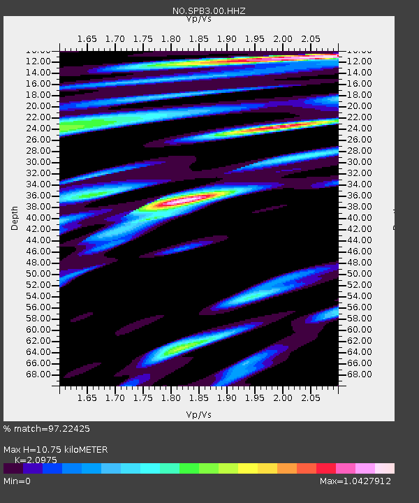
SPB3 - Earthquake Result Viewer
| Earthquake location: |
Komandorskiye Ostrova Region |
| Earthquake latitude/longitude: |
54.8/164.8 |
| Earthquake time(UTC): |
2018/12/20 (354) 17:01:56 GMT |
| Earthquake Depth: |
33 km |
| Earthquake Magnitude: |
7.3 Mi |
| Earthquake Catalog/Contributor: |
NEIC PDE/pt |
|
| Network: |
NO Norwegian Seismic Array Network |
| Station: |
SPB3 |
| Lat/Lon: |
78.17 N/16.36 E |
| Elevation: |
234 m |
|
| Distance: |
45.8 deg |
| Az: |
351.353 deg |
| Baz: |
24.932 deg |
| Ray Param: |
0.0709479 |
| Estimated Moho Depth: |
10.75 km |
| Estimated Crust Vp/Vs: |
2.10 |
| Assumed Crust Vp: |
6.545 km/s |
| Estimated Crust Vs: |
3.121 km/s |
| Estimated Crust Poisson's Ratio: |
0.35 |
|
| Radial Match: |
97.22425 % |
| Radial Bump: |
370 |
| Transverse Match: |
91.8561 % |
| Transverse Bump: |
400 |
| SOD ConfigId: |
3201911 |
| Insert Time: |
2019-01-03 17:16:15.479 +0000 |
| GWidth: |
2.5 |
| Max Bumps: |
400 |
| Tol: |
0.001 |
|

Signal To Noise
| Channel | StoN | STA | LTA |
| NO:SPB3:00:HHZ:20181220T17:09:44.386993Z | 68.30665 | 1.1639282E-5 | 1.703975E-7 |
| NO:SPB3:00:HHN:20181220T17:09:44.386993Z | 47.418095 | 6.6437387E-6 | 1.4010978E-7 |
| NO:SPB3:00:HHE:20181220T17:09:44.386993Z | 21.774374 | 2.831115E-6 | 1.300205E-7 |
| Arrivals |
| Ps | 1.9 SECOND |
| PpPs | 4.8 SECOND |
| PsPs/PpSs | 6.7 SECOND |


