You are here: Home > Network List > AK - Alaska Regional Network Stations List
> Station G17K Kiwalik Mountain, AK, USA > Earthquake Result Viewer
G17K Kiwalik Mountain, AK, USA - Earthquake Result Viewer
| Earthquake location: |
South Of Mariana Islands |
| Earthquake latitude/longitude: |
13.4/147.5 |
| Earthquake time(UTC): |
2023/08/14 (226) 13:51:54 GMT |
| Earthquake Depth: |
10 km |
| Earthquake Magnitude: |
6.1 mww |
| Earthquake Catalog/Contributor: |
NEIC PDE/us |
|
| Network: |
AK Alaska Regional Network |
| Station: |
G17K Kiwalik Mountain, AK, USA |
| Lat/Lon: |
65.50 N/160.65 W |
| Elevation: |
338 m |
|
| Distance: |
62.6 deg |
| Az: |
21.658 deg |
| Baz: |
239.47 deg |
| Ray Param: |
0.060108986 |
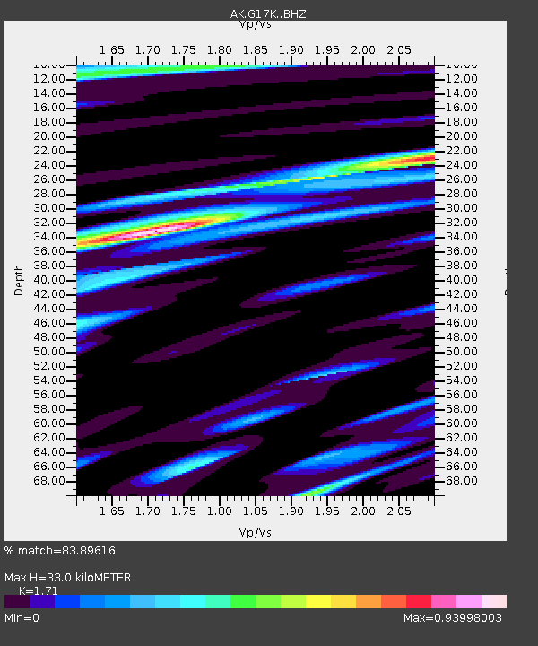
| Estimated Moho Depth: |
33.0 km |
| Estimated Crust Vp/Vs: |
1.71 |
| Assumed Crust Vp: |
6.276 km/s |
| Estimated Crust Vs: |
3.67 km/s |
| Estimated Crust Poisson's Ratio: |
0.24 |
|
| Radial Match: |
83.89616 % |
| Radial Bump: |
400 |
| Transverse Match: |
71.29339 % |
| Transverse Bump: |
400 |
| SOD ConfigId: |
31937991 |
| Insert Time: |
2023-08-28 13:54:42.046 +0000 |
| GWidth: |
2.5 |
| Max Bumps: |
400 |
| Tol: |
0.001 |
|

Signal To Noise
| Channel | StoN | STA | LTA |
| AK:G17K: :BHZ:20230814T14:01:47.499971Z | 3.3759756 | 3.4312103E-7 | 1.0163611E-7 |
| AK:G17K: :BHN:20230814T14:01:47.499971Z | 0.68828803 | 5.9141815E-8 | 8.592597E-8 |
| AK:G17K: :BHE:20230814T14:01:47.499971Z | 1.4734392 | 1.16465465E-7 | 7.904328E-8 |
| Arrivals |
| Ps | 3.9 SECOND |
| PpPs | 14 SECOND |
| PsPs/PpSs | 18 SECOND |


