You are here: Home > Network List > NO - Norwegian Seismic Array Network Stations List
> Station SPB5 > Earthquake Result Viewer
SPB5 - Earthquake Result Viewer
| Earthquake location: |
Komandorskiye Ostrova Region |
| Earthquake latitude/longitude: |
54.8/164.8 |
| Earthquake time(UTC): |
2018/12/20 (354) 17:01:56 GMT |
| Earthquake Depth: |
33 km |
| Earthquake Magnitude: |
7.3 Mi |
| Earthquake Catalog/Contributor: |
NEIC PDE/pt |
|
| Network: |
NO Norwegian Seismic Array Network |
| Station: |
SPB5 |
| Lat/Lon: |
78.18 N/16.37 E |
| Elevation: |
295 m |
|
| Distance: |
45.8 deg |
| Az: |
351.355 deg |
| Baz: |
24.943 deg |
| Ray Param: |
0.07095328 |
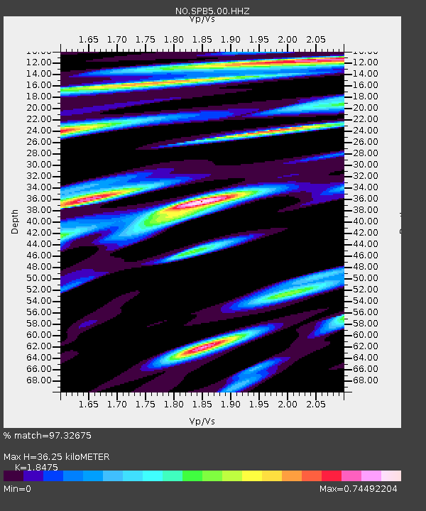
| Estimated Moho Depth: |
36.25 km |
| Estimated Crust Vp/Vs: |
1.85 |
| Assumed Crust Vp: |
6.545 km/s |
| Estimated Crust Vs: |
3.543 km/s |
| Estimated Crust Poisson's Ratio: |
0.29 |
|
| Radial Match: |
97.32675 % |
| Radial Bump: |
400 |
| Transverse Match: |
93.32075 % |
| Transverse Bump: |
400 |
| SOD ConfigId: |
3201911 |
| Insert Time: |
2019-01-03 17:16:18.886 +0000 |
| GWidth: |
2.5 |
| Max Bumps: |
400 |
| Tol: |
0.001 |
|

Signal To Noise
| Channel | StoN | STA | LTA |
| NO:SPB5:00:HHZ:20181220T17:09:44.312012Z | 65.27205 | 1.1138292E-5 | 1.7064413E-7 |
| NO:SPB5:00:HHN:20181220T17:09:44.312012Z | 41.143166 | 5.8630367E-6 | 1.425033E-7 |
| NO:SPB5:00:HHE:20181220T17:09:44.312012Z | 22.947386 | 3.5389864E-6 | 1.5422178E-7 |
| Arrivals |
| Ps | 5.0 SECOND |
| PpPs | 15 SECOND |
| PsPs/PpSs | 20 SECOND |


