You are here: Home > Network List > OK - Oklahoma Seismic Network Stations List
> Station FNO Franklin, Norman, OK > Earthquake Result Viewer
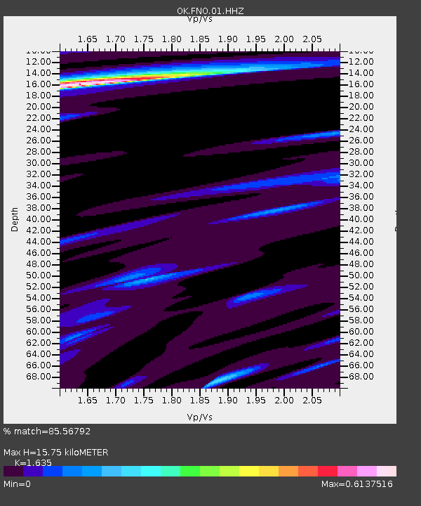
FNO Franklin, Norman, OK - Earthquake Result Viewer
| Earthquake location: |
Komandorskiye Ostrova Region |
| Earthquake latitude/longitude: |
54.8/164.8 |
| Earthquake time(UTC): |
2018/12/20 (354) 17:01:56 GMT |
| Earthquake Depth: |
33 km |
| Earthquake Magnitude: |
7.3 Mi |
| Earthquake Catalog/Contributor: |
NEIC PDE/pt |
|
| Network: |
OK Oklahoma Seismic Network |
| Station: |
FNO Franklin, Norman, OK |
| Lat/Lon: |
35.26 N/97.40 W |
| Elevation: |
360 m |
|
| Distance: |
66.1 deg |
| Az: |
62.472 deg |
| Baz: |
321.197 deg |
| Ray Param: |
0.05777185 |
| Estimated Moho Depth: |
15.75 km |
| Estimated Crust Vp/Vs: |
1.63 |
| Assumed Crust Vp: |
6.426 km/s |
| Estimated Crust Vs: |
3.93 km/s |
| Estimated Crust Poisson's Ratio: |
0.20 |
|
| Radial Match: |
85.56792 % |
| Radial Bump: |
393 |
| Transverse Match: |
84.983986 % |
| Transverse Bump: |
383 |
| SOD ConfigId: |
3201911 |
| Insert Time: |
2019-01-03 17:16:26.763 +0000 |
| GWidth: |
2.5 |
| Max Bumps: |
400 |
| Tol: |
0.001 |
|

Signal To Noise
| Channel | StoN | STA | LTA |
| OK:FNO:01:HHZ:20181220T17:12:09.093994Z | 4.6275964 | 4.5786414E-6 | 9.894211E-7 |
| OK:FNO:01:HHN:20181220T17:12:09.093994Z | 1.163512 | 2.2110717E-8 | 1.9003428E-8 |
| OK:FNO:01:HHE:20181220T17:12:09.093994Z | 1.0470052 | 1.8080062E-6 | 1.726836E-6 |
| Arrivals |
| Ps | 1.6 SECOND |
| PpPs | 6.2 SECOND |
| PsPs/PpSs | 7.8 SECOND |


