You are here: Home > Network List > TX - Texas Seismological Network Stations List
> Station BRDY Brady > Earthquake Result Viewer
BRDY Brady - Earthquake Result Viewer
| Earthquake location: |
Komandorskiye Ostrova Region |
| Earthquake latitude/longitude: |
54.8/164.8 |
| Earthquake time(UTC): |
2018/12/20 (354) 17:01:56 GMT |
| Earthquake Depth: |
33 km |
| Earthquake Magnitude: |
7.3 Mi |
| Earthquake Catalog/Contributor: |
NEIC PDE/pt |
|
| Network: |
TX Texas Seismological Network |
| Station: |
BRDY Brady |
| Lat/Lon: |
31.27 N/99.00 W |
| Elevation: |
460 m |
|
| Distance: |
68.4 deg |
| Az: |
66.295 deg |
| Baz: |
321.8 deg |
| Ray Param: |
0.05628074 |
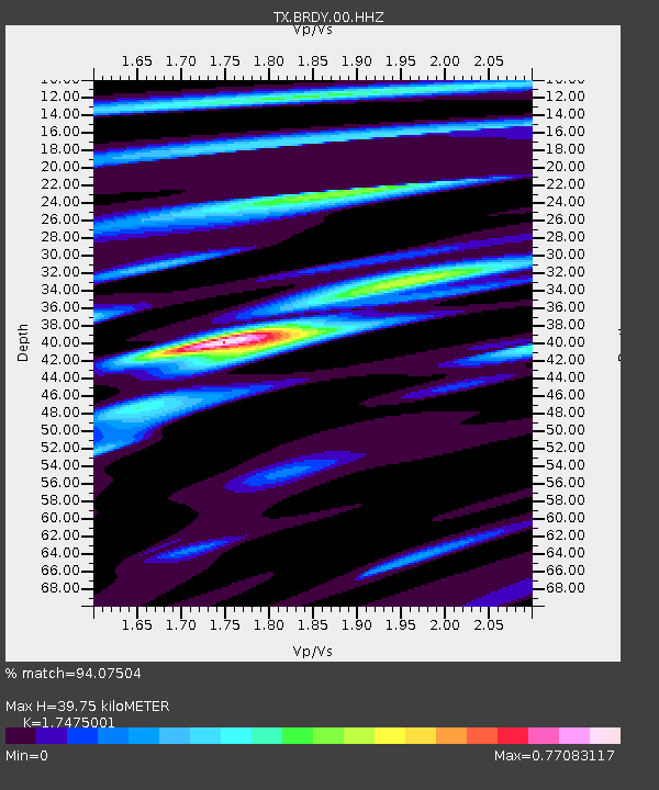
| Estimated Moho Depth: |
39.75 km |
| Estimated Crust Vp/Vs: |
1.75 |
| Assumed Crust Vp: |
6.498 km/s |
| Estimated Crust Vs: |
3.718 km/s |
| Estimated Crust Poisson's Ratio: |
0.26 |
|
| Radial Match: |
94.07504 % |
| Radial Bump: |
337 |
| Transverse Match: |
73.2696 % |
| Transverse Bump: |
400 |
| SOD ConfigId: |
3201911 |
| Insert Time: |
2019-01-03 17:16:36.738 +0000 |
| GWidth: |
2.5 |
| Max Bumps: |
400 |
| Tol: |
0.001 |
|

Signal To Noise
| Channel | StoN | STA | LTA |
| TX:BRDY:00:HHZ:20181220T17:12:23.414978Z | 3.4081233 | 2.2766071E-6 | 6.6799436E-7 |
| TX:BRDY:00:HH1:20181220T17:12:23.414978Z | 1.7227651 | 6.62726E-7 | 3.8468738E-7 |
| TX:BRDY:00:HH2:20181220T17:12:23.414978Z | 3.4024498 | 1.0902792E-6 | 3.2043945E-7 |
| Arrivals |
| Ps | 4.8 SECOND |
| PpPs | 16 SECOND |
| PsPs/PpSs | 21 SECOND |


