You are here: Home > Network List > TX - Texas Seismological Network Stations List
> Station DRZT Darrouzett > Earthquake Result Viewer
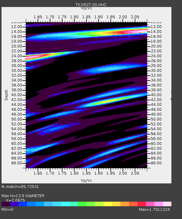
DRZT Darrouzett - Earthquake Result Viewer
| Earthquake location: |
Komandorskiye Ostrova Region |
| Earthquake latitude/longitude: |
54.8/164.8 |
| Earthquake time(UTC): |
2018/12/20 (354) 17:01:56 GMT |
| Earthquake Depth: |
33 km |
| Earthquake Magnitude: |
7.3 Mi |
| Earthquake Catalog/Contributor: |
NEIC PDE/pt |
|
| Network: |
TX Texas Seismological Network |
| Station: |
DRZT Darrouzett |
| Lat/Lon: |
36.44 N/100.30 W |
| Elevation: |
791 m |
|
| Distance: |
63.7 deg |
| Az: |
63.649 deg |
| Baz: |
320.007 deg |
| Ray Param: |
0.059344392 |
| Estimated Moho Depth: |
13.5 km |
| Estimated Crust Vp/Vs: |
2.10 |
| Assumed Crust Vp: |
6.483 km/s |
| Estimated Crust Vs: |
3.091 km/s |
| Estimated Crust Poisson's Ratio: |
0.35 |
|
| Radial Match: |
85.72531 % |
| Radial Bump: |
400 |
| Transverse Match: |
67.193954 % |
| Transverse Bump: |
400 |
| SOD ConfigId: |
3201911 |
| Insert Time: |
2019-01-03 17:16:43.313 +0000 |
| GWidth: |
2.5 |
| Max Bumps: |
400 |
| Tol: |
0.001 |
|

Signal To Noise
| Channel | StoN | STA | LTA |
| TX:DRZT:00:HHZ:20181220T17:11:53.469971Z | 2.4361353 | 2.7626165E-6 | 1.1340161E-6 |
| TX:DRZT:00:HH1:20181220T17:11:53.469971Z | 0.7655544 | 8.211865E-7 | 1.072669E-6 |
| TX:DRZT:00:HH2:20181220T17:11:53.469971Z | 1.0442489 | 1.1182935E-6 | 1.070907E-6 |
| Arrivals |
| Ps | 2.4 SECOND |
| PpPs | 6.2 SECOND |
| PsPs/PpSs | 8.6 SECOND |


