You are here: Home > Network List > CI - Caltech Regional Seismic Network Stations List
> Station SLA SLA, Trona, CA, USA > Earthquake Result Viewer
SLA SLA, Trona, CA, USA - Earthquake Result Viewer
| Earthquake location: |
South Of Mariana Islands |
| Earthquake latitude/longitude: |
11.1/146.0 |
| Earthquake time(UTC): |
2010/07/10 (191) 11:43:32 GMT |
| Earthquake Depth: |
13 km |
| Earthquake Magnitude: |
6.2 MB, 6.1 MS, 6.3 MW, 6.3 MW |
| Earthquake Catalog/Contributor: |
WHDF/NEIC |
|
| Network: |
CI Caltech Regional Seismic Network |
| Station: |
SLA SLA, Trona, CA, USA |
| Lat/Lon: |
35.89 N/117.28 W |
| Elevation: |
1174 m |
|
| Distance: |
88.9 deg |
| Az: |
53.762 deg |
| Baz: |
282.883 deg |
| Ray Param: |
0.042222887 |
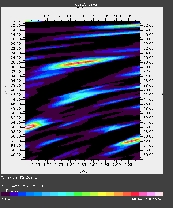
| Estimated Moho Depth: |
55.75 km |
| Estimated Crust Vp/Vs: |
1.61 |
| Assumed Crust Vp: |
6.276 km/s |
| Estimated Crust Vs: |
3.898 km/s |
| Estimated Crust Poisson's Ratio: |
0.19 |
|
| Radial Match: |
92.26945 % |
| Radial Bump: |
400 |
| Transverse Match: |
82.08075 % |
| Transverse Bump: |
400 |
| SOD ConfigId: |
319893 |
| Insert Time: |
2011-01-05 01:31:24.312 +0000 |
| GWidth: |
2.5 |
| Max Bumps: |
400 |
| Tol: |
0.001 |
|
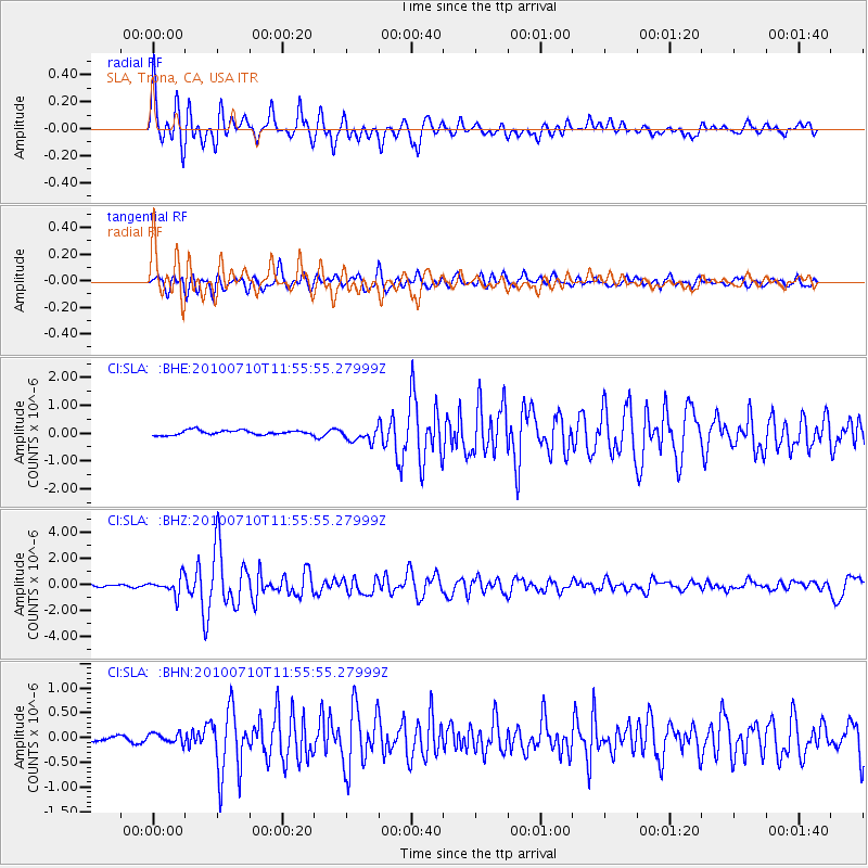
Signal To Noise
| Channel | StoN | STA | LTA |
| CI:SLA: :BHZ:20100710T11:55:55.27999Z | 9.413533 | 6.6287936E-7 | 7.04177E-8 |
| CI:SLA: :BHN:20100710T11:55:55.27999Z | 1.1493775 | 9.990785E-8 | 8.692345E-8 |
| CI:SLA: :BHE:20100710T11:55:55.27999Z | 3.136522 | 2.5737828E-7 | 8.205849E-8 |
| Arrivals |
| Ps | 5.5 SECOND |
| PpPs | 23 SECOND |
| PsPs/PpSs | 28 SECOND |


