You are here: Home > Network List > AV - Alaska Volcano Observatory Stations List
> Station ETKA Kagalaska Island, Regional Station, Alaska > Earthquake Result Viewer
ETKA Kagalaska Island, Regional Station, Alaska - Earthquake Result Viewer
| Earthquake location: |
South Of Mariana Islands |
| Earthquake latitude/longitude: |
13.4/147.5 |
| Earthquake time(UTC): |
2023/08/14 (226) 13:51:54 GMT |
| Earthquake Depth: |
10 km |
| Earthquake Magnitude: |
6.1 mww |
| Earthquake Catalog/Contributor: |
NEIC PDE/us |
|
| Network: |
AV Alaska Volcano Observatory |
| Station: |
ETKA Kagalaska Island, Regional Station, Alaska |
| Lat/Lon: |
51.86 N/176.41 W |
| Elevation: |
290 m |
|
| Distance: |
48.1 deg |
| Az: |
29.38 deg |
| Baz: |
230.347 deg |
| Ray Param: |
0.06961245 |
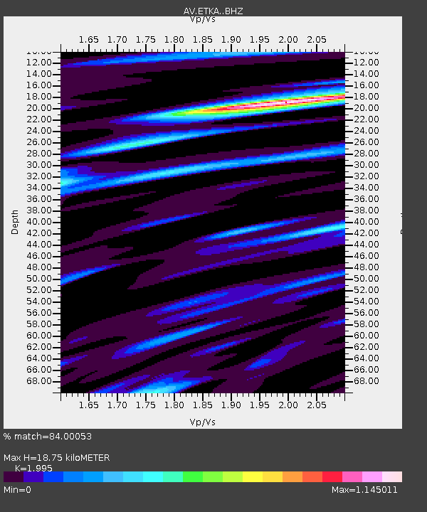
| Estimated Moho Depth: |
18.75 km |
| Estimated Crust Vp/Vs: |
2.00 |
| Assumed Crust Vp: |
5.88 km/s |
| Estimated Crust Vs: |
2.948 km/s |
| Estimated Crust Poisson's Ratio: |
0.33 |
|
| Radial Match: |
84.00053 % |
| Radial Bump: |
400 |
| Transverse Match: |
80.29615 % |
| Transverse Bump: |
400 |
| SOD ConfigId: |
31937991 |
| Insert Time: |
2023-08-28 13:59:26.245 +0000 |
| GWidth: |
2.5 |
| Max Bumps: |
400 |
| Tol: |
0.001 |
|

Signal To Noise
| Channel | StoN | STA | LTA |
| AV:ETKA: :BHZ:20230814T14:00:02.819002Z | 2.5734332 | 6.8863295E-7 | 2.6759312E-7 |
| AV:ETKA: :BHN:20230814T14:00:02.819002Z | 0.97955173 | 2.8879757E-7 | 2.9482626E-7 |
| AV:ETKA: :BHE:20230814T14:00:02.819002Z | 1.6459633 | 3.080854E-7 | 1.8717634E-7 |
| Arrivals |
| Ps | 3.3 SECOND |
| PpPs | 9.1 SECOND |
| PsPs/PpSs | 12 SECOND |


