You are here: Home > Network List > CI - Caltech Regional Seismic Network Stations List
> Station VES Vestal, Richgrove, CA, USA > Earthquake Result Viewer
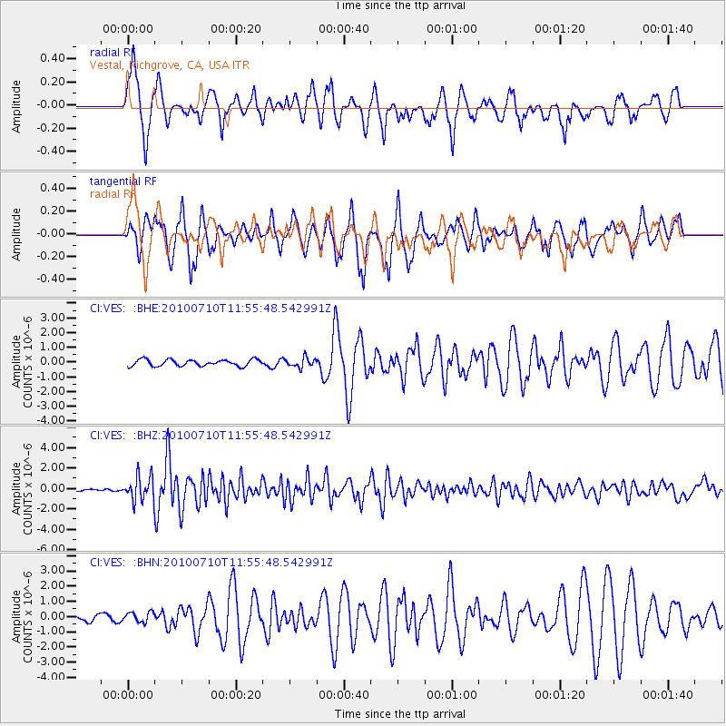
VES Vestal, Richgrove, CA, USA - Earthquake Result Viewer

| Earthquake location: |
South Of Mariana Islands |
| Earthquake latitude/longitude: |
11.1/146.0 |
| Earthquake time(UTC): |
2010/07/10 (191) 11:43:32 GMT |
| Earthquake Depth: |
13 km |
| Earthquake Magnitude: |
6.2 MB, 6.1 MS, 6.3 MW, 6.3 MW |
| Earthquake Catalog/Contributor: |
WHDF/NEIC |
|
| Network: |
CI Caltech Regional Seismic Network |
| Station: |
VES Vestal, Richgrove, CA, USA |
| Lat/Lon: |
35.84 N/119.08 W |
| Elevation: |
154 m |
|
| Distance: |
87.5 deg |
| Az: |
54.124 deg |
| Baz: |
281.843 deg |
| Ray Param: |
0.0432762 |
| Estimated Moho Depth: |
13.0 km |
| Estimated Crust Vp/Vs: |
1.80 |
| Assumed Crust Vp: |
6.1 km/s |
| Estimated Crust Vs: |
3.384 km/s |
| Estimated Crust Poisson's Ratio: |
0.28 |
|
| Radial Match: |
90.93368 % |
| Radial Bump: |
381 |
| Transverse Match: |
83.92647 % |
| Transverse Bump: |
368 |
| SOD ConfigId: |
319893 |
| Insert Time: |
2011-01-05 01:31:42.705 +0000 |
| GWidth: |
2.5 |
| Max Bumps: |
400 |
| Tol: |
0.001 |
|
Signal To Noise
| Channel | StoN | STA | LTA |
| CI:VES: :BHZ:20100710T11:55:48.542991Z | 16.703033 | 1.1960248E-6 | 7.1605236E-8 |
| CI:VES: :BHN:20100710T11:55:48.542991Z | 1.2074205 | 3.3473071E-7 | 2.7722794E-7 |
| CI:VES: :BHE:20100710T11:55:48.542991Z | 1.4411607 | 3.1709533E-7 | 2.2002776E-7 |
| Arrivals |
| Ps | 1.7 SECOND |
| PpPs | 5.9 SECOND |
| PsPs/PpSs | 7.6 SECOND |


