You are here: Home > Network List > CN - Canadian National Seismograph Network Stations List
> Station LLLB LILLOOET, BC, CANADA ADA > Earthquake Result Viewer
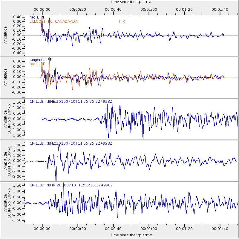
LLLB LILLOOET, BC, CANADA ADA - Earthquake Result Viewer
*The percent match for this event was below the threshold and hence no stack was calculated.
| Earthquake location: |
South Of Mariana Islands |
| Earthquake latitude/longitude: |
11.1/146.0 |
| Earthquake time(UTC): |
2010/07/10 (191) 11:43:32 GMT |
| Earthquake Depth: |
13 km |
| Earthquake Magnitude: |
6.2 MB, 6.1 MS, 6.3 MW, 6.3 MW |
| Earthquake Catalog/Contributor: |
WHDF/NEIC |
|
| Network: |
CN Canadian National Seismograph Network |
| Station: |
LLLB LILLOOET, BC, CANADA ADA |
| Lat/Lon: |
50.61 N/121.88 W |
| Elevation: |
700 m |
|
| Distance: |
82.8 deg |
| Az: |
39.922 deg |
| Baz: |
278.714 deg |
| Ray Param: |
$rayparam |
*The percent match for this event was below the threshold and hence was not used in the summary stack. |
|
| Radial Match: |
82.15336 % |
| Radial Bump: |
400 |
| Transverse Match: |
85.33667 % |
| Transverse Bump: |
400 |
| SOD ConfigId: |
319893 |
| Insert Time: |
2011-01-05 01:34:03.688 +0000 |
| GWidth: |
2.5 |
| Max Bumps: |
400 |
| Tol: |
0.001 |
|
Signal To Noise
| Channel | StoN | STA | LTA |
| CN:LLLB: :BHZ:20100710T11:55:25.224998Z | 5.3708167 | 5.039775E-7 | 9.3836285E-8 |
| CN:LLLB: :BHN:20100710T11:55:25.224998Z | 3.4901323 | 1.5784565E-7 | 4.5226265E-8 |
| CN:LLLB: :BHE:20100710T11:55:25.224998Z | 2.6627536 | 1.5936901E-7 | 5.98512E-8 |
| Arrivals |
| Ps | |
| PpPs | |
| PsPs/PpSs | |


