You are here: Home > Network List > TX - Texas Seismological Network Stations List
> Station VHRN Van Horn > Earthquake Result Viewer
VHRN Van Horn - Earthquake Result Viewer
| Earthquake location: |
Komandorskiye Ostrova Region |
| Earthquake latitude/longitude: |
54.8/164.8 |
| Earthquake time(UTC): |
2018/12/20 (354) 17:01:56 GMT |
| Earthquake Depth: |
33 km |
| Earthquake Magnitude: |
7.3 Mi |
| Earthquake Catalog/Contributor: |
NEIC PDE/pt |
|
| Network: |
TX Texas Seismological Network |
| Station: |
VHRN Van Horn |
| Lat/Lon: |
30.79 N/104.99 W |
| Elevation: |
1342 m |
|
| Distance: |
65.6 deg |
| Az: |
70.969 deg |
| Baz: |
320.56 deg |
| Ray Param: |
0.058144063 |
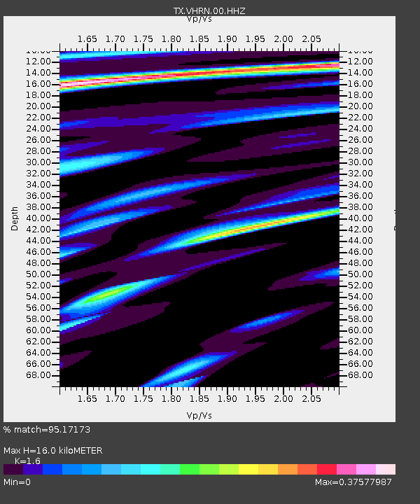
| Estimated Moho Depth: |
16.0 km |
| Estimated Crust Vp/Vs: |
1.60 |
| Assumed Crust Vp: |
6.361 km/s |
| Estimated Crust Vs: |
3.975 km/s |
| Estimated Crust Poisson's Ratio: |
0.18 |
|
| Radial Match: |
95.17173 % |
| Radial Bump: |
313 |
| Transverse Match: |
77.60774 % |
| Transverse Bump: |
400 |
| SOD ConfigId: |
3201911 |
| Insert Time: |
2019-01-03 17:17:46.699 +0000 |
| GWidth: |
2.5 |
| Max Bumps: |
400 |
| Tol: |
0.001 |
|

Signal To Noise
| Channel | StoN | STA | LTA |
| TX:VHRN:00:HHZ:20181220T17:12:05.450012Z | 2.9564216 | 1.6472602E-6 | 5.571804E-7 |
| TX:VHRN:00:HH1:20181220T17:12:05.450012Z | 1.18342 | 4.384661E-7 | 3.7050762E-7 |
| TX:VHRN:00:HH2:20181220T17:12:05.450012Z | 0.99136484 | 6.58845E-7 | 6.645838E-7 |
| Arrivals |
| Ps | 1.6 SECOND |
| PpPs | 6.3 SECOND |
| PsPs/PpSs | 7.8 SECOND |


