You are here: Home > Network List > US - United States National Seismic Network Stations List
> Station BLA Blacksburg, Virginia, USA > Earthquake Result Viewer
BLA Blacksburg, Virginia, USA - Earthquake Result Viewer
| Earthquake location: |
Komandorskiye Ostrova Region |
| Earthquake latitude/longitude: |
54.8/164.8 |
| Earthquake time(UTC): |
2018/12/20 (354) 17:01:56 GMT |
| Earthquake Depth: |
33 km |
| Earthquake Magnitude: |
7.3 Mi |
| Earthquake Catalog/Contributor: |
NEIC PDE/pt |
|
| Network: |
US United States National Seismic Network |
| Station: |
BLA Blacksburg, Virginia, USA |
| Lat/Lon: |
37.21 N/80.42 W |
| Elevation: |
634 m |
|
| Distance: |
72.7 deg |
| Az: |
49.421 deg |
| Baz: |
326.621 deg |
| Ray Param: |
0.05346301 |
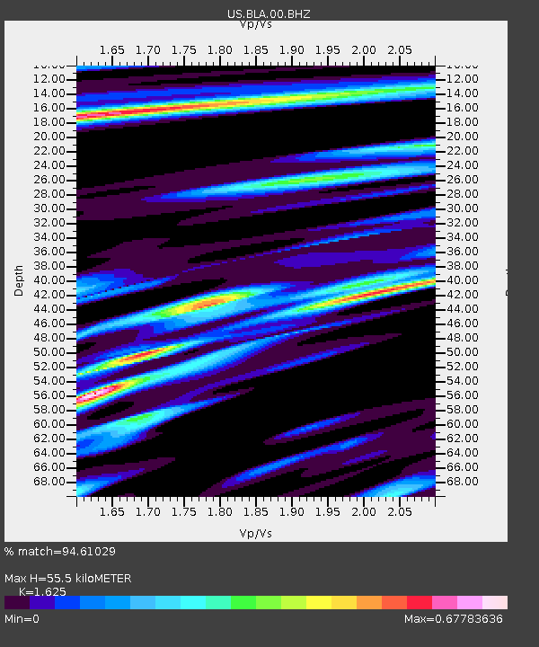
| Estimated Moho Depth: |
55.5 km |
| Estimated Crust Vp/Vs: |
1.62 |
| Assumed Crust Vp: |
6.159 km/s |
| Estimated Crust Vs: |
3.79 km/s |
| Estimated Crust Poisson's Ratio: |
0.20 |
|
| Radial Match: |
94.61029 % |
| Radial Bump: |
362 |
| Transverse Match: |
86.92097 % |
| Transverse Bump: |
400 |
| SOD ConfigId: |
3201911 |
| Insert Time: |
2019-01-03 17:18:03.503 +0000 |
| GWidth: |
2.5 |
| Max Bumps: |
400 |
| Tol: |
0.001 |
|
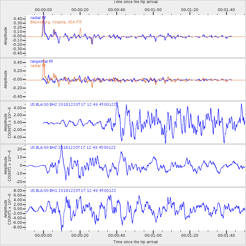
Signal To Noise
| Channel | StoN | STA | LTA |
| US:BLA:00:BHZ:20181220T17:12:49.450012Z | 10.76956 | 4.0706045E-6 | 3.7797315E-7 |
| US:BLA:00:BH1:20181220T17:12:49.450012Z | 2.9857206 | 1.6676529E-6 | 5.5854287E-7 |
| US:BLA:00:BH2:20181220T17:12:49.450012Z | 1.8910574 | 8.29192E-7 | 4.384806E-7 |
| Arrivals |
| Ps | 5.8 SECOND |
| PpPs | 23 SECOND |
| PsPs/PpSs | 29 SECOND |


