You are here: Home > Network List > US - United States National Seismic Network Stations List
> Station EGMT Eagleton, Montana, USA > Earthquake Result Viewer
EGMT Eagleton, Montana, USA - Earthquake Result Viewer
| Earthquake location: |
Komandorskiye Ostrova Region |
| Earthquake latitude/longitude: |
54.8/164.8 |
| Earthquake time(UTC): |
2018/12/20 (354) 17:01:56 GMT |
| Earthquake Depth: |
33 km |
| Earthquake Magnitude: |
7.3 Mi |
| Earthquake Catalog/Contributor: |
NEIC PDE/pt |
|
| Network: |
US United States National Seismic Network |
| Station: |
EGMT Eagleton, Montana, USA |
| Lat/Lon: |
48.02 N/109.75 W |
| Elevation: |
1055 m |
|
| Distance: |
50.5 deg |
| Az: |
60.093 deg |
| Baz: |
311.689 deg |
| Ray Param: |
0.06793008 |
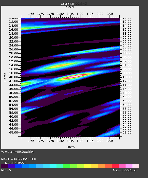
| Estimated Moho Depth: |
39.5 km |
| Estimated Crust Vp/Vs: |
1.87 |
| Assumed Crust Vp: |
6.438 km/s |
| Estimated Crust Vs: |
3.438 km/s |
| Estimated Crust Poisson's Ratio: |
0.30 |
|
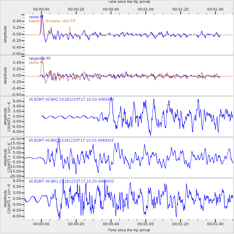
| Radial Match: |
89.266884 % |
| Radial Bump: |
377 |
| Transverse Match: |
67.72619 % |
| Transverse Bump: |
400 |
| SOD ConfigId: |
3201911 |
| Insert Time: |
2019-01-03 17:18:20.747 +0000 |
| GWidth: |
2.5 |
| Max Bumps: |
400 |
| Tol: |
0.001 |
|
Signal To Noise
| Channel | StoN | STA | LTA |
| US:EGMT:00:BHZ:20181220T17:10:20.498993Z | 8.243002 | 3.9954184E-6 | 4.847043E-7 |
| US:EGMT:00:BH1:20181220T17:10:20.498993Z | 1.706196 | 1.7993789E-6 | 1.0546145E-6 |
| US:EGMT:00:BH2:20181220T17:10:20.498993Z | 2.3912508 | 1.2648077E-6 | 5.289314E-7 |
| Arrivals |
| Ps | 5.7 SECOND |
| PpPs | 17 SECOND |
| PsPs/PpSs | 22 SECOND |


