You are here: Home > Network List > AK - Alaska Regional Network Stations List
> Station GHO Gloryhole, AK, USA > Earthquake Result Viewer
GHO Gloryhole, AK, USA - Earthquake Result Viewer
| Earthquake location: |
Vanuatu Islands |
| Earthquake latitude/longitude: |
-13.9/167.2 |
| Earthquake time(UTC): |
2023/08/16 (228) 12:47:40 GMT |
| Earthquake Depth: |
193 km |
| Earthquake Magnitude: |
6.5 Mww |
| Earthquake Catalog/Contributor: |
NEIC PDE/us |
|
| Network: |
AK Alaska Regional Network |
| Station: |
GHO Gloryhole, AK, USA |
| Lat/Lon: |
61.77 N/148.92 W |
| Elevation: |
1038 m |
|
| Distance: |
82.9 deg |
| Az: |
19.409 deg |
| Baz: |
222.748 deg |
| Ray Param: |
0.046074484 |
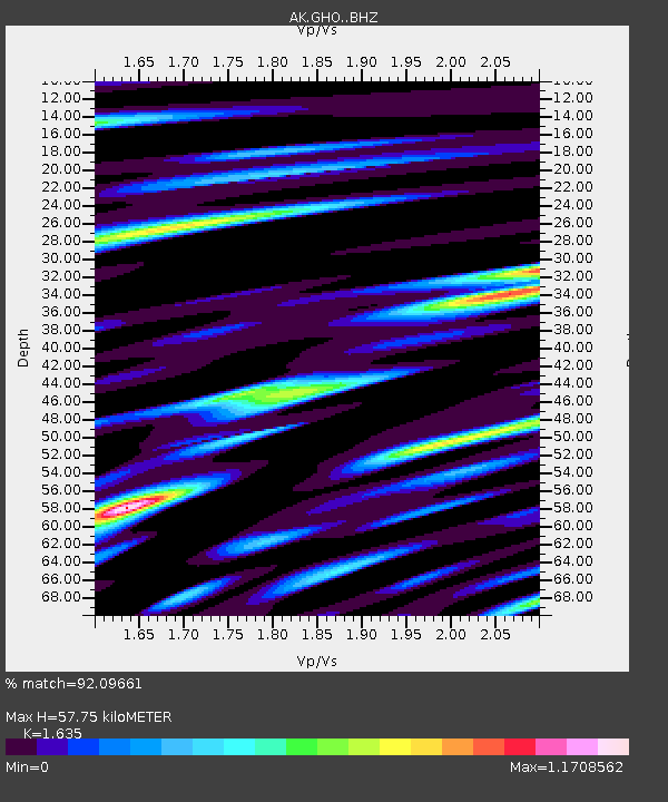
| Estimated Moho Depth: |
57.75 km |
| Estimated Crust Vp/Vs: |
1.63 |
| Assumed Crust Vp: |
6.566 km/s |
| Estimated Crust Vs: |
4.016 km/s |
| Estimated Crust Poisson's Ratio: |
0.20 |
|
| Radial Match: |
92.09661 % |
| Radial Bump: |
400 |
| Transverse Match: |
82.02189 % |
| Transverse Bump: |
400 |
| SOD ConfigId: |
31937991 |
| Insert Time: |
2023-08-30 12:51:47.129 +0000 |
| GWidth: |
2.5 |
| Max Bumps: |
400 |
| Tol: |
0.001 |
|

Signal To Noise
| Channel | StoN | STA | LTA |
| AK:GHO: :BHZ:20230816T12:59:12.548011Z | 28.910206 | 3.2059584E-6 | 1.10893644E-7 |
| AK:GHO: :BHN:20230816T12:59:12.548011Z | 12.519805 | 1.3360036E-6 | 1.0671122E-7 |
| AK:GHO: :BHE:20230816T12:59:12.548011Z | 6.287904 | 9.5362685E-7 | 1.5166054E-7 |
| Arrivals |
| Ps | 5.7 SECOND |
| PpPs | 23 SECOND |
| PsPs/PpSs | 28 SECOND |


