You are here: Home > Network List > TA - USArray Transportable Network (new EarthScope stations) Stations List
> Station I20A Worland, WY, USA > Earthquake Result Viewer
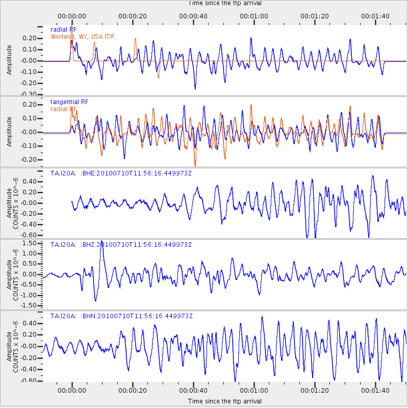
I20A Worland, WY, USA - Earthquake Result Viewer
*The percent match for this event was below the threshold and hence no stack was calculated.
| Earthquake location: |
South Of Mariana Islands |
| Earthquake latitude/longitude: |
11.1/146.0 |
| Earthquake time(UTC): |
2010/07/10 (191) 11:43:32 GMT |
| Earthquake Depth: |
13 km |
| Earthquake Magnitude: |
6.2 MB, 6.1 MS, 6.3 MW, 6.3 MW |
| Earthquake Catalog/Contributor: |
WHDF/NEIC |
|
| Network: |
TA USArray Transportable Network (new EarthScope stations) |
| Station: |
I20A Worland, WY, USA |
| Lat/Lon: |
43.95 N/108.13 W |
| Elevation: |
1342 m |
|
| Distance: |
93.5 deg |
| Az: |
44.11 deg |
| Baz: |
288.961 deg |
| Ray Param: |
$rayparam |
*The percent match for this event was below the threshold and hence was not used in the summary stack. |
|
| Radial Match: |
69.10472 % |
| Radial Bump: |
400 |
| Transverse Match: |
68.87956 % |
| Transverse Bump: |
400 |
| SOD ConfigId: |
319893 |
| Insert Time: |
2011-01-05 01:40:12.259 +0000 |
| GWidth: |
2.5 |
| Max Bumps: |
400 |
| Tol: |
0.001 |
|
Signal To Noise
| Channel | StoN | STA | LTA |
| TA:I20A: :BHZ:20100710T11:56:16.449973Z | 3.1101286 | 2.2494285E-7 | 7.2325896E-8 |
| TA:I20A: :BHN:20100710T11:56:16.449973Z | 0.92131275 | 8.2576186E-8 | 8.9628834E-8 |
| TA:I20A: :BHE:20100710T11:56:16.449973Z | 1.5756205 | 8.673777E-8 | 5.5049913E-8 |
| Arrivals |
| Ps | |
| PpPs | |
| PsPs/PpSs | |


