You are here: Home > Network List > TA - USArray Transportable Network (new EarthScope stations) Stations List
> Station I21A Big Trails, Ten Sleep, WY, USA > Earthquake Result Viewer
I21A Big Trails, Ten Sleep, WY, USA - Earthquake Result Viewer

| Earthquake location: |
South Of Mariana Islands |
| Earthquake latitude/longitude: |
11.1/146.0 |
| Earthquake time(UTC): |
2010/07/10 (191) 11:43:32 GMT |
| Earthquake Depth: |
13 km |
| Earthquake Magnitude: |
6.2 MB, 6.1 MS, 6.3 MW, 6.3 MW |
| Earthquake Catalog/Contributor: |
WHDF/NEIC |
|
| Network: |
TA USArray Transportable Network (new EarthScope stations) |
| Station: |
I21A Big Trails, Ten Sleep, WY, USA |
| Lat/Lon: |
43.81 N/107.29 W |
| Elevation: |
1639 m |
|
| Distance: |
94.1 deg |
| Az: |
44.04 deg |
| Baz: |
289.543 deg |
| Ray Param: |
0.041116986 |
| Estimated Moho Depth: |
67.0 km |
| Estimated Crust Vp/Vs: |
1.61 |
| Assumed Crust Vp: |
6.178 km/s |
| Estimated Crust Vs: |
3.849 km/s |
| Estimated Crust Poisson's Ratio: |
0.18 |
|
| Radial Match: |
84.609055 % |
| Radial Bump: |
400 |
| Transverse Match: |
82.0502 % |
| Transverse Bump: |
400 |
| SOD ConfigId: |
319893 |
| Insert Time: |
2011-01-05 01:40:21.629 +0000 |
| GWidth: |
2.5 |
| Max Bumps: |
400 |
| Tol: |
0.001 |
|
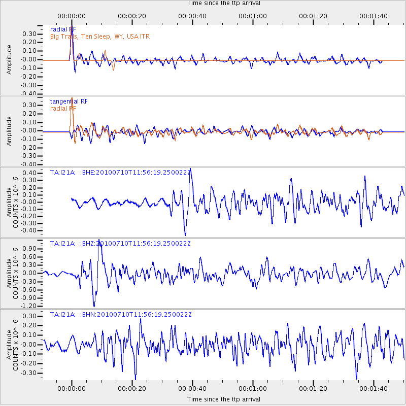
Signal To Noise
| Channel | StoN | STA | LTA |
| TA:I21A: :BHZ:20100710T11:56:19.250022Z | 3.5838187 | 1.9141052E-7 | 5.3409657E-8 |
| TA:I21A: :BHN:20100710T11:56:19.250022Z | 1.9488418 | 5.6471105E-8 | 2.8976752E-8 |
| TA:I21A: :BHE:20100710T11:56:19.250022Z | 2.0260966 | 7.527187E-8 | 3.7151178E-8 |
| Arrivals |
| Ps | 6.7 SECOND |
| PpPs | 28 SECOND |
| PsPs/PpSs | 34 SECOND |


