You are here: Home > Network List > AK - Alaska Regional Network Stations List
> Station J20K Nowitna River, AK, USA > Earthquake Result Viewer
J20K Nowitna River, AK, USA - Earthquake Result Viewer
| Earthquake location: |
Vanuatu Islands |
| Earthquake latitude/longitude: |
-13.9/167.2 |
| Earthquake time(UTC): |
2023/08/16 (228) 12:47:40 GMT |
| Earthquake Depth: |
193 km |
| Earthquake Magnitude: |
6.5 Mww |
| Earthquake Catalog/Contributor: |
NEIC PDE/us |
|
| Network: |
AK Alaska Regional Network |
| Station: |
J20K Nowitna River, AK, USA |
| Lat/Lon: |
64.18 N/154.15 W |
| Elevation: |
314 m |
|
| Distance: |
83.2 deg |
| Az: |
16.005 deg |
| Baz: |
217.691 deg |
| Ray Param: |
0.045859464 |
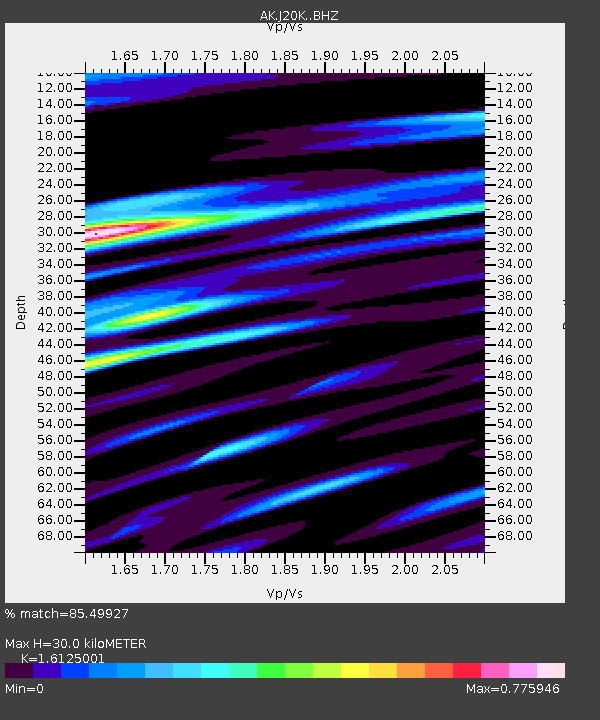
| Estimated Moho Depth: |
30.0 km |
| Estimated Crust Vp/Vs: |
1.61 |
| Assumed Crust Vp: |
6.566 km/s |
| Estimated Crust Vs: |
4.072 km/s |
| Estimated Crust Poisson's Ratio: |
0.19 |
|
| Radial Match: |
85.49927 % |
| Radial Bump: |
400 |
| Transverse Match: |
81.959015 % |
| Transverse Bump: |
400 |
| SOD ConfigId: |
31937991 |
| Insert Time: |
2023-08-30 12:52:23.611 +0000 |
| GWidth: |
2.5 |
| Max Bumps: |
400 |
| Tol: |
0.001 |
|

Signal To Noise
| Channel | StoN | STA | LTA |
| AK:J20K: :BHZ:20230816T12:59:14.079993Z | 46.548428 | 2.4926815E-6 | 5.3550284E-8 |
| AK:J20K: :BHN:20230816T12:59:14.079993Z | 14.164007 | 8.5308267E-7 | 6.0228906E-8 |
| AK:J20K: :BHE:20230816T12:59:14.079993Z | 7.5899854 | 5.7771655E-7 | 7.611563E-8 |
| Arrivals |
| Ps | 2.9 SECOND |
| PpPs | 12 SECOND |
| PsPs/PpSs | 14 SECOND |


