You are here: Home > Network List > TA - USArray Transportable Network (new EarthScope stations) Stations List
> Station B19A Brinkman Farms, Chinook, MT, USA > Earthquake Result Viewer
B19A Brinkman Farms, Chinook, MT, USA - Earthquake Result Viewer
| Earthquake location: |
South Of Mariana Islands |
| Earthquake latitude/longitude: |
11.1/146.0 |
| Earthquake time(UTC): |
2010/07/10 (191) 11:43:32 GMT |
| Earthquake Depth: |
13 km |
| Earthquake Magnitude: |
6.2 MB, 6.1 MS, 6.3 MW, 6.3 MW |
| Earthquake Catalog/Contributor: |
WHDF/NEIC |
|
| Network: |
TA USArray Transportable Network (new EarthScope stations) |
| Station: |
B19A Brinkman Farms, Chinook, MT, USA |
| Lat/Lon: |
48.46 N/108.94 W |
| Elevation: |
803 m |
|
| Distance: |
91.5 deg |
| Az: |
40.021 deg |
| Baz: |
288.553 deg |
| Ray Param: |
0.04159611 |
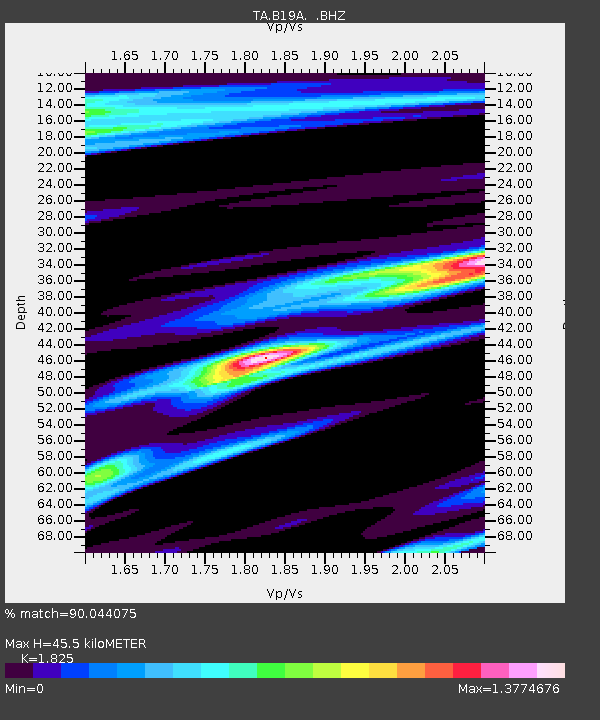
| Estimated Moho Depth: |
45.5 km |
| Estimated Crust Vp/Vs: |
1.83 |
| Assumed Crust Vp: |
6.438 km/s |
| Estimated Crust Vs: |
3.527 km/s |
| Estimated Crust Poisson's Ratio: |
0.29 |
|
| Radial Match: |
90.044075 % |
| Radial Bump: |
400 |
| Transverse Match: |
79.5833 % |
| Transverse Bump: |
400 |
| SOD ConfigId: |
319893 |
| Insert Time: |
2011-01-05 01:41:16.477 +0000 |
| GWidth: |
2.5 |
| Max Bumps: |
400 |
| Tol: |
0.001 |
|

Signal To Noise
| Channel | StoN | STA | LTA |
| TA:B19A: :BHZ:20100710T11:56:07.324973Z | 8.870421 | 5.497284E-7 | 6.1973196E-8 |
| TA:B19A: :BHN:20100710T11:56:07.324973Z | 0.8200912 | 9.7261356E-8 | 1.1859822E-7 |
| TA:B19A: :BHE:20100710T11:56:07.324973Z | 1.2405777 | 1.614451E-7 | 1.3013704E-7 |
| Arrivals |
| Ps | 5.9 SECOND |
| PpPs | 20 SECOND |
| PsPs/PpSs | 26 SECOND |


