You are here: Home > Network List > TA - USArray Transportable Network (new EarthScope stations) Stations List
> Station C22A Vida, MT, USA > Earthquake Result Viewer
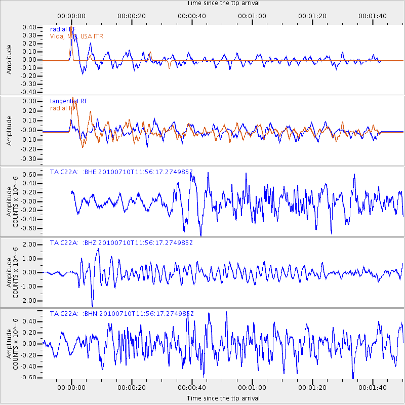
C22A Vida, MT, USA - Earthquake Result Viewer
*The percent match for this event was below the threshold and hence no stack was calculated.
| Earthquake location: |
South Of Mariana Islands |
| Earthquake latitude/longitude: |
11.1/146.0 |
| Earthquake time(UTC): |
2010/07/10 (191) 11:43:32 GMT |
| Earthquake Depth: |
13 km |
| Earthquake Magnitude: |
6.2 MB, 6.1 MS, 6.3 MW, 6.3 MW |
| Earthquake Catalog/Contributor: |
WHDF/NEIC |
|
| Network: |
TA USArray Transportable Network (new EarthScope stations) |
| Station: |
C22A Vida, MT, USA |
| Lat/Lon: |
47.75 N/105.88 W |
| Elevation: |
745 m |
|
| Distance: |
93.7 deg |
| Az: |
39.998 deg |
| Baz: |
290.825 deg |
| Ray Param: |
$rayparam |
*The percent match for this event was below the threshold and hence was not used in the summary stack. |
|
| Radial Match: |
77.92508 % |
| Radial Bump: |
400 |
| Transverse Match: |
69.2969 % |
| Transverse Bump: |
400 |
| SOD ConfigId: |
319893 |
| Insert Time: |
2011-01-05 01:41:38.759 +0000 |
| GWidth: |
2.5 |
| Max Bumps: |
400 |
| Tol: |
0.001 |
|
Signal To Noise
| Channel | StoN | STA | LTA |
| TA:C22A: :BHZ:20100710T11:56:17.274985Z | 5.4733357 | 4.4704944E-7 | 8.167769E-8 |
| TA:C22A: :BHN:20100710T11:56:17.274985Z | 0.7681014 | 9.678632E-8 | 1.2600722E-7 |
| TA:C22A: :BHE:20100710T11:56:17.274985Z | 1.5368177 | 1.7008101E-7 | 1.1067091E-7 |
| Arrivals |
| Ps | |
| PpPs | |
| PsPs/PpSs | |


