You are here: Home > Network List > TA - USArray Transportable Network (new EarthScope stations) Stations List
> Station H26A Fairpoint, SD, USA > Earthquake Result Viewer
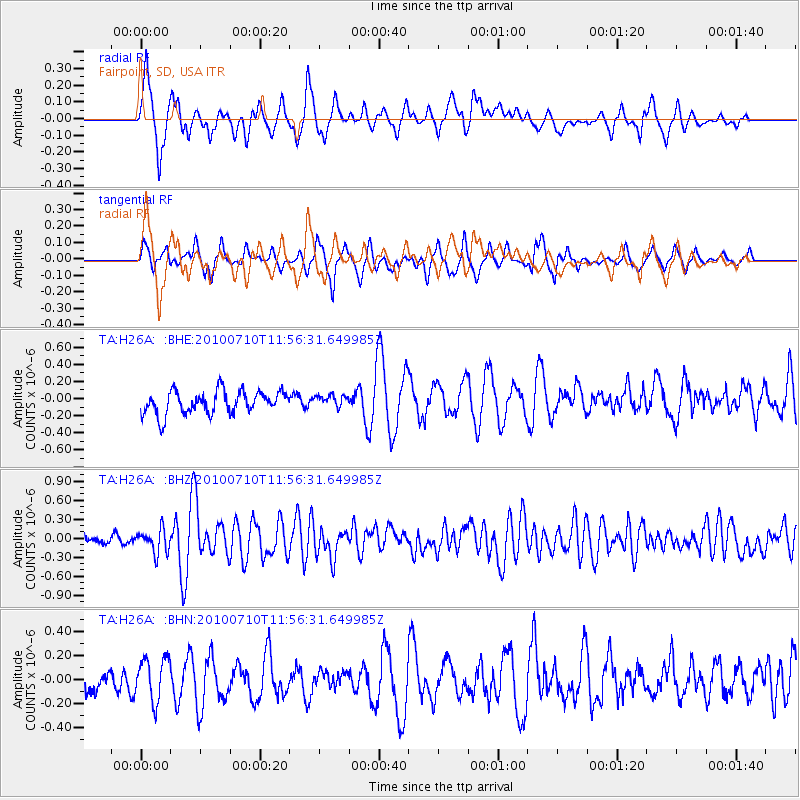
H26A Fairpoint, SD, USA - Earthquake Result Viewer
*The percent match for this event was below the threshold and hence no stack was calculated.
| Earthquake location: |
South Of Mariana Islands |
| Earthquake latitude/longitude: |
11.1/146.0 |
| Earthquake time(UTC): |
2010/07/10 (191) 11:43:32 GMT |
| Earthquake Depth: |
13 km |
| Earthquake Magnitude: |
6.2 MB, 6.1 MS, 6.3 MW, 6.3 MW |
| Earthquake Catalog/Contributor: |
WHDF/NEIC |
|
| Network: |
TA USArray Transportable Network (new EarthScope stations) |
| Station: |
H26A Fairpoint, SD, USA |
| Lat/Lon: |
44.62 N/102.77 W |
| Elevation: |
879 m |
|
| Distance: |
96.9 deg |
| Az: |
42.107 deg |
| Baz: |
292.869 deg |
| Ray Param: |
$rayparam |
*The percent match for this event was below the threshold and hence was not used in the summary stack. |
|
| Radial Match: |
69.61438 % |
| Radial Bump: |
400 |
| Transverse Match: |
68.695526 % |
| Transverse Bump: |
352 |
| SOD ConfigId: |
319893 |
| Insert Time: |
2011-01-05 01:44:01.031 +0000 |
| GWidth: |
2.5 |
| Max Bumps: |
400 |
| Tol: |
0.001 |
|
Signal To Noise
| Channel | StoN | STA | LTA |
| TA:H26A: :BHZ:20100710T11:56:31.649985Z | 3.2600248 | 1.8700148E-7 | 5.7361977E-8 |
| TA:H26A: :BHN:20100710T11:56:31.649985Z | 1.5102919 | 1.7612048E-7 | 1.1661354E-7 |
| TA:H26A: :BHE:20100710T11:56:31.649985Z | 0.5274706 | 7.026434E-8 | 1.3320998E-7 |
| Arrivals |
| Ps | |
| PpPs | |
| PsPs/PpSs | |


