You are here: Home > Network List > CI - Caltech Regional Seismic Network Stations List
> Station BEL Belle Mtn, Joshua Tree National Park, CA, USA > Earthquake Result Viewer
BEL Belle Mtn, Joshua Tree National Park, CA, USA - Earthquake Result Viewer
| Earthquake location: |
Vanuatu Islands |
| Earthquake latitude/longitude: |
-13.9/167.2 |
| Earthquake time(UTC): |
2023/08/16 (228) 12:47:40 GMT |
| Earthquake Depth: |
193 km |
| Earthquake Magnitude: |
6.5 Mww |
| Earthquake Catalog/Contributor: |
NEIC PDE/us |
|
| Network: |
CI Caltech Regional Seismic Network |
| Station: |
BEL Belle Mtn, Joshua Tree National Park, CA, USA |
| Lat/Lon: |
34.00 N/116.00 W |
| Elevation: |
1388 m |
|
| Distance: |
87.1 deg |
| Az: |
54.097 deg |
| Baz: |
251.246 deg |
| Ray Param: |
0.043141253 |
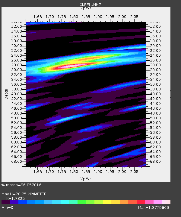
| Estimated Moho Depth: |
28.25 km |
| Estimated Crust Vp/Vs: |
1.78 |
| Assumed Crust Vp: |
6.276 km/s |
| Estimated Crust Vs: |
3.521 km/s |
| Estimated Crust Poisson's Ratio: |
0.27 |
|
| Radial Match: |
96.057816 % |
| Radial Bump: |
316 |
| Transverse Match: |
92.860085 % |
| Transverse Bump: |
394 |
| SOD ConfigId: |
31937991 |
| Insert Time: |
2023-08-30 13:03:15.943 +0000 |
| GWidth: |
2.5 |
| Max Bumps: |
400 |
| Tol: |
0.001 |
|
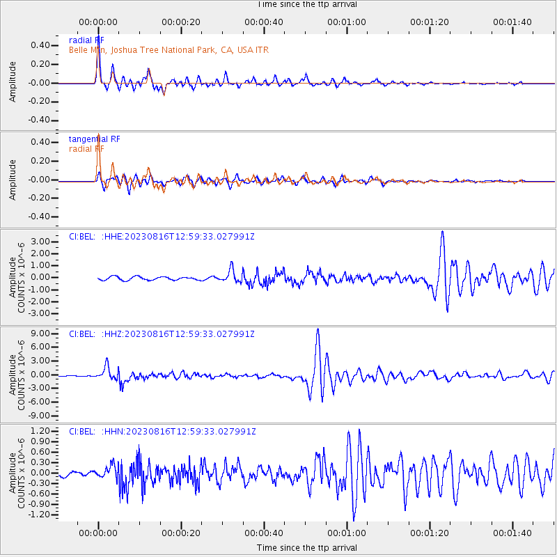
Signal To Noise
| Channel | StoN | STA | LTA |
| CI:BEL: :HHZ:20230816T12:59:33.027991Z | 18.263372 | 1.4608974E-6 | 7.999056E-8 |
| CI:BEL: :HHN:20230816T12:59:33.027991Z | 1.9482621 | 1.883367E-7 | 9.6669076E-8 |
| CI:BEL: :HHE:20230816T12:59:33.027991Z | 3.7724578 | 5.273886E-7 | 1.3979972E-7 |
| Arrivals |
| Ps | 3.6 SECOND |
| PpPs | 12 SECOND |
| PsPs/PpSs | 16 SECOND |


