You are here: Home > Network List > UW - Pacific Northwest Regional Seismic Network Stations List
> Station MRBL Marblemount, WA, USA > Earthquake Result Viewer
MRBL Marblemount, WA, USA - Earthquake Result Viewer
| Earthquake location: |
South Of Mariana Islands |
| Earthquake latitude/longitude: |
11.1/146.0 |
| Earthquake time(UTC): |
2010/07/10 (191) 11:43:32 GMT |
| Earthquake Depth: |
13 km |
| Earthquake Magnitude: |
6.2 MB, 6.1 MS, 6.3 MW, 6.3 MW |
| Earthquake Catalog/Contributor: |
WHDF/NEIC |
|
| Network: |
UW Pacific Northwest Regional Seismic Network |
| Station: |
MRBL Marblemount, WA, USA |
| Lat/Lon: |
48.52 N/121.48 W |
| Elevation: |
75 m |
|
| Distance: |
83.4 deg |
| Az: |
41.963 deg |
| Baz: |
279.26 deg |
| Ray Param: |
0.046203446 |
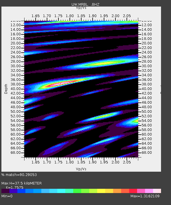
| Estimated Moho Depth: |
37.5 km |
| Estimated Crust Vp/Vs: |
1.76 |
| Assumed Crust Vp: |
6.566 km/s |
| Estimated Crust Vs: |
3.736 km/s |
| Estimated Crust Poisson's Ratio: |
0.26 |
|
| Radial Match: |
90.29053 % |
| Radial Bump: |
400 |
| Transverse Match: |
85.94668 % |
| Transverse Bump: |
400 |
| SOD ConfigId: |
319893 |
| Insert Time: |
2011-01-05 01:48:37.846 +0000 |
| GWidth: |
2.5 |
| Max Bumps: |
400 |
| Tol: |
0.001 |
|
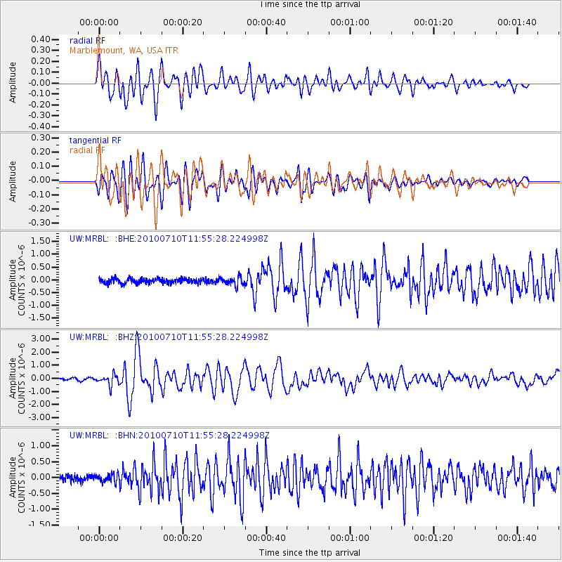
Signal To Noise
| Channel | StoN | STA | LTA |
| UW:MRBL: :BHZ:20100710T11:55:28.224998Z | 7.418415 | 4.0965668E-7 | 5.522159E-8 |
| UW:MRBL: :BHN:20100710T11:55:28.224998Z | 1.6087784 | 1.2610566E-7 | 7.838598E-8 |
| UW:MRBL: :BHE:20100710T11:55:28.224998Z | 1.7338095 | 1.6503787E-7 | 9.518801E-8 |
| Arrivals |
| Ps | 4.4 SECOND |
| PpPs | 15 SECOND |
| PsPs/PpSs | 20 SECOND |


