You are here: Home > Network List > WY - Yellowstone Wyoming Seismic Network Stations List
> Station YHH Holmes Hill, YNP, WY, USA > Earthquake Result Viewer
YHH Holmes Hill, YNP, WY, USA - Earthquake Result Viewer

| Earthquake location: |
Komandorskiye Ostrova Region |
| Earthquake latitude/longitude: |
54.8/164.8 |
| Earthquake time(UTC): |
2018/12/20 (354) 17:01:56 GMT |
| Earthquake Depth: |
33 km |
| Earthquake Magnitude: |
7.3 Mi |
| Earthquake Catalog/Contributor: |
NEIC PDE/pt |
|
| Network: |
WY Yellowstone Wyoming Seismic Network |
| Station: |
YHH Holmes Hill, YNP, WY, USA |
| Lat/Lon: |
44.79 N/110.85 W |
| Elevation: |
2717 m |
|
| Distance: |
52.2 deg |
| Az: |
63.806 deg |
| Baz: |
313.218 deg |
| Ray Param: |
0.06687949 |
| Estimated Moho Depth: |
25.0 km |
| Estimated Crust Vp/Vs: |
2.00 |
| Assumed Crust Vp: |
6.35 km/s |
| Estimated Crust Vs: |
3.183 km/s |
| Estimated Crust Poisson's Ratio: |
0.33 |
|
| Radial Match: |
91.69216 % |
| Radial Bump: |
400 |
| Transverse Match: |
81.45406 % |
| Transverse Bump: |
400 |
| SOD ConfigId: |
3201911 |
| Insert Time: |
2019-01-03 17:20:42.558 +0000 |
| GWidth: |
2.5 |
| Max Bumps: |
400 |
| Tol: |
0.001 |
|
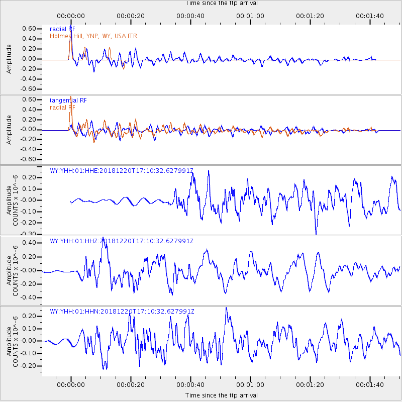
Signal To Noise
| Channel | StoN | STA | LTA |
| WY:YHH:01:HHZ:20181220T17:10:32.627991Z | 4.1312323 | 6.7869365E-8 | 1.642836E-8 |
| WY:YHH:01:HHN:20181220T17:10:32.627991Z | 4.3761477 | 4.6416304E-8 | 1.0606658E-8 |
| WY:YHH:01:HHE:20181220T17:10:32.627991Z | 1.3895594 | 2.5238199E-8 | 1.8162735E-8 |
| Arrivals |
| Ps | 4.1 SECOND |
| PpPs | 11 SECOND |
| PsPs/PpSs | 15 SECOND |


