You are here: Home > Network List > S1 - Australian Seismometers in Schools Stations List
> Station AUBRN Burnie High School > Earthquake Result Viewer
AUBRN Burnie High School - Earthquake Result Viewer
| Earthquake location: |
Vanuatu Islands |
| Earthquake latitude/longitude: |
-13.9/167.2 |
| Earthquake time(UTC): |
2023/08/16 (228) 12:47:40 GMT |
| Earthquake Depth: |
193 km |
| Earthquake Magnitude: |
6.5 Mww |
| Earthquake Catalog/Contributor: |
NEIC PDE/us |
|
| Network: |
S1 Australian Seismometers in Schools |
| Station: |
AUBRN Burnie High School |
| Lat/Lon: |
41.04 S/145.87 E |
| Elevation: |
10 m |
|
| Distance: |
32.8 deg |
| Az: |
210.45 deg |
| Baz: |
40.591 deg |
| Ray Param: |
0.07788528 |
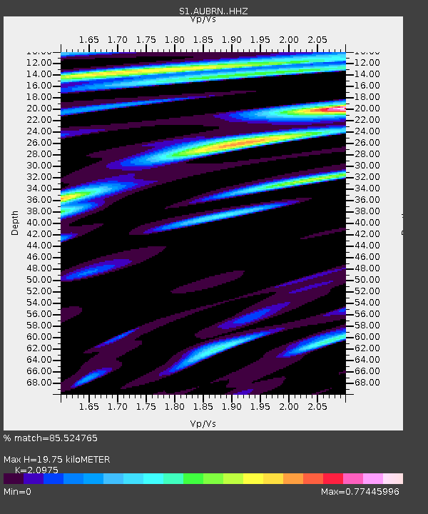
| Estimated Moho Depth: |
19.75 km |
| Estimated Crust Vp/Vs: |
2.10 |
| Assumed Crust Vp: |
6.477 km/s |
| Estimated Crust Vs: |
3.088 km/s |
| Estimated Crust Poisson's Ratio: |
0.35 |
|
| Radial Match: |
85.524765 % |
| Radial Bump: |
268 |
| Transverse Match: |
59.972664 % |
| Transverse Bump: |
400 |
| SOD ConfigId: |
31937991 |
| Insert Time: |
2023-08-30 13:14:04.384 +0000 |
| GWidth: |
2.5 |
| Max Bumps: |
400 |
| Tol: |
0.001 |
|

Signal To Noise
| Channel | StoN | STA | LTA |
| S1:AUBRN: :HHZ:20230816T12:53:25.280005Z | 12.585716 | 1.0803759E-5 | 8.5841435E-7 |
| S1:AUBRN: :HHN:20230816T12:53:25.280005Z | 6.797505 | 6.45759E-6 | 9.499942E-7 |
| S1:AUBRN: :HHE:20230816T12:53:25.280005Z | 5.200208 | 4.2538973E-6 | 8.180243E-7 |
| Arrivals |
| Ps | 3.6 SECOND |
| PpPs | 8.8 SECOND |
| PsPs/PpSs | 12 SECOND |


