You are here: Home > Network List > TA - USArray Transportable Network (new EarthScope stations) Stations List
> Station I20A Worland, WY, USA > Earthquake Result Viewer
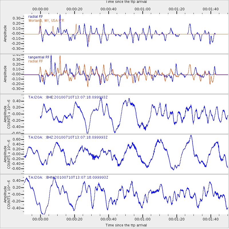
I20A Worland, WY, USA - Earthquake Result Viewer
*The percent match for this event was below the threshold and hence no stack was calculated.
| Earthquake location: |
Solomon Islands |
| Earthquake latitude/longitude: |
-7.9/158.7 |
| Earthquake time(UTC): |
2010/07/10 (191) 12:54:19 GMT |
| Earthquake Depth: |
47 km |
| Earthquake Magnitude: |
5.7 MB, 5.4 MS, 5.7 MW |
| Earthquake Catalog/Contributor: |
WHDF/NEIC |
|
| Network: |
TA USArray Transportable Network (new EarthScope stations) |
| Station: |
I20A Worland, WY, USA |
| Lat/Lon: |
43.95 N/108.13 W |
| Elevation: |
1342 m |
|
| Distance: |
97.7 deg |
| Az: |
46.693 deg |
| Baz: |
266.508 deg |
| Ray Param: |
$rayparam |
*The percent match for this event was below the threshold and hence was not used in the summary stack. |
|
| Radial Match: |
66.77708 % |
| Radial Bump: |
400 |
| Transverse Match: |
51.322575 % |
| Transverse Bump: |
400 |
| SOD ConfigId: |
319893 |
| Insert Time: |
2011-01-05 01:55:20.365 +0000 |
| GWidth: |
2.5 |
| Max Bumps: |
400 |
| Tol: |
0.001 |
|
Signal To Noise
| Channel | StoN | STA | LTA |
| TA:I20A: :BHZ:20100710T13:07:18.099993Z | 1.031746 | 2.8662555E-7 | 2.7780632E-7 |
| TA:I20A: :BHN:20100710T13:07:18.099993Z | 2.6030982 | 4.8775235E-7 | 1.8737379E-7 |
| TA:I20A: :BHE:20100710T13:07:18.099993Z | 0.9069774 | 1.5102026E-7 | 1.6650938E-7 |
| Arrivals |
| Ps | |
| PpPs | |
| PsPs/PpSs | |


