You are here: Home > Network List > UU - University of Utah Regional Network Stations List
> Station CTU Camp Tracy, UT, USA > Earthquake Result Viewer
CTU Camp Tracy, UT, USA - Earthquake Result Viewer
| Earthquake location: |
Vanuatu Islands |
| Earthquake latitude/longitude: |
-13.9/167.2 |
| Earthquake time(UTC): |
2023/08/16 (228) 12:47:40 GMT |
| Earthquake Depth: |
193 km |
| Earthquake Magnitude: |
6.5 Mww |
| Earthquake Catalog/Contributor: |
NEIC PDE/us |
|
| Network: |
UU University of Utah Regional Network |
| Station: |
CTU Camp Tracy, UT, USA |
| Lat/Lon: |
40.69 N/111.75 W |
| Elevation: |
1731 m |
|
| Distance: |
92.3 deg |
| Az: |
48.749 deg |
| Baz: |
253.789 deg |
| Ray Param: |
0.041374125 |
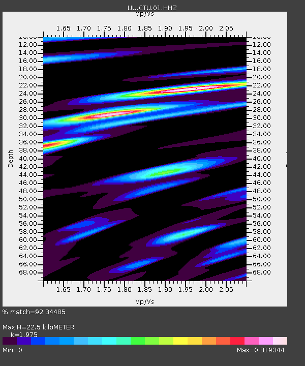
| Estimated Moho Depth: |
22.5 km |
| Estimated Crust Vp/Vs: |
1.98 |
| Assumed Crust Vp: |
6.155 km/s |
| Estimated Crust Vs: |
3.116 km/s |
| Estimated Crust Poisson's Ratio: |
0.33 |
|
| Radial Match: |
92.34485 % |
| Radial Bump: |
388 |
| Transverse Match: |
85.31251 % |
| Transverse Bump: |
400 |
| SOD ConfigId: |
31937991 |
| Insert Time: |
2023-08-30 13:18:35.552 +0000 |
| GWidth: |
2.5 |
| Max Bumps: |
400 |
| Tol: |
0.001 |
|

Signal To Noise
| Channel | StoN | STA | LTA |
| UU:CTU:01:HHZ:20230816T12:59:57.41001Z | 12.973035 | 6.863664E-7 | 5.2907158E-8 |
| UU:CTU:01:HHN:20230816T12:59:57.41001Z | 2.1043212 | 7.557938E-8 | 3.5916276E-8 |
| UU:CTU:01:HHE:20230816T12:59:57.41001Z | 4.6688776 | 2.1326176E-7 | 4.5677307E-8 |
| Arrivals |
| Ps | 3.6 SECOND |
| PpPs | 11 SECOND |
| PsPs/PpSs | 14 SECOND |


