You are here: Home > Network List > UW - Pacific Northwest Regional Seismic Network Stations List
> Station IRON Crane, OR, USA > Earthquake Result Viewer
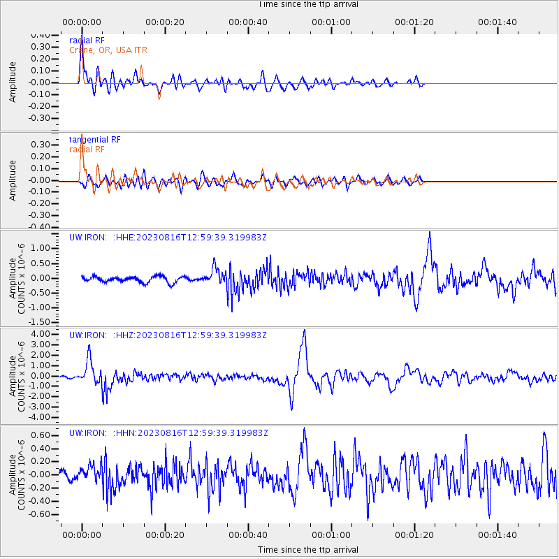
IRON Crane, OR, USA - Earthquake Result Viewer
| Earthquake location: |
Vanuatu Islands |
| Earthquake latitude/longitude: |
-13.9/167.2 |
| Earthquake time(UTC): |
2023/08/16 (228) 12:47:40 GMT |
| Earthquake Depth: |
193 km |
| Earthquake Magnitude: |
6.5 Mww |
| Earthquake Catalog/Contributor: |
NEIC PDE/us |
|
| Network: |
UW Pacific Northwest Regional Seismic Network |
| Station: |
IRON Crane, OR, USA |
| Lat/Lon: |
43.36 N/118.47 W |
| Elevation: |
1226 m |
|
| Distance: |
88.4 deg |
| Az: |
44.641 deg |
| Baz: |
249.326 deg |
| Ray Param: |
0.04217114 |
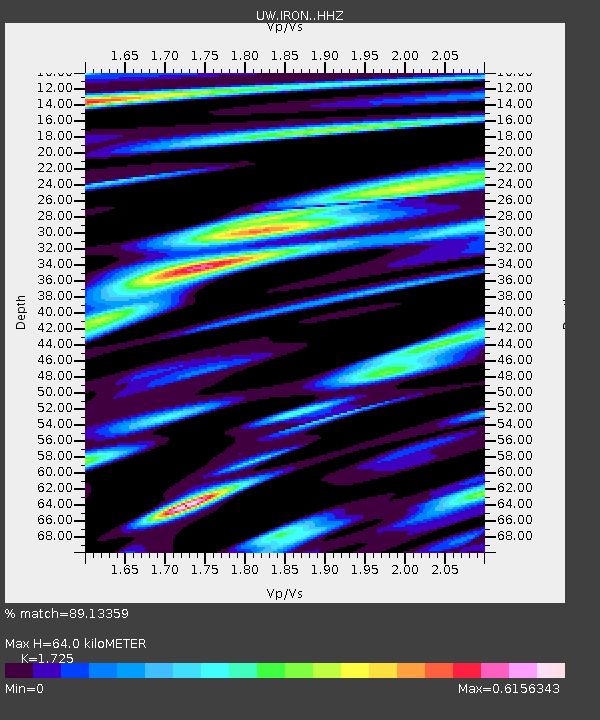
| Estimated Moho Depth: |
64.0 km |
| Estimated Crust Vp/Vs: |
1.73 |
| Assumed Crust Vp: |
6.279 km/s |
| Estimated Crust Vs: |
3.64 km/s |
| Estimated Crust Poisson's Ratio: |
0.25 |
|
| Radial Match: |
89.13359 % |
| Radial Bump: |
400 |
| Transverse Match: |
80.01177 % |
| Transverse Bump: |
400 |
| SOD ConfigId: |
31937991 |
| Insert Time: |
2023-08-30 13:20:45.151 +0000 |
| GWidth: |
2.5 |
| Max Bumps: |
400 |
| Tol: |
0.001 |
|
Signal To Noise
| Channel | StoN | STA | LTA |
| UW:IRON: :HHZ:20230816T12:59:39.319983Z | 10.7973995 | 1.1747928E-6 | 1.0880331E-7 |
| UW:IRON: :HHN:20230816T12:59:39.319983Z | 1.6329641 | 1.2280904E-7 | 7.520621E-8 |
| UW:IRON: :HHE:20230816T12:59:39.319983Z | 2.7577472 | 2.7141544E-7 | 9.8419264E-8 |
| Arrivals |
| Ps | 7.5 SECOND |
| PpPs | 27 SECOND |
| PsPs/PpSs | 35 SECOND |


