You are here: Home > Network List > IU - Global Seismograph Network (GSN - IRIS/USGS) Stations List
> Station CTAO Charters Towers, Australia > Earthquake Result Viewer
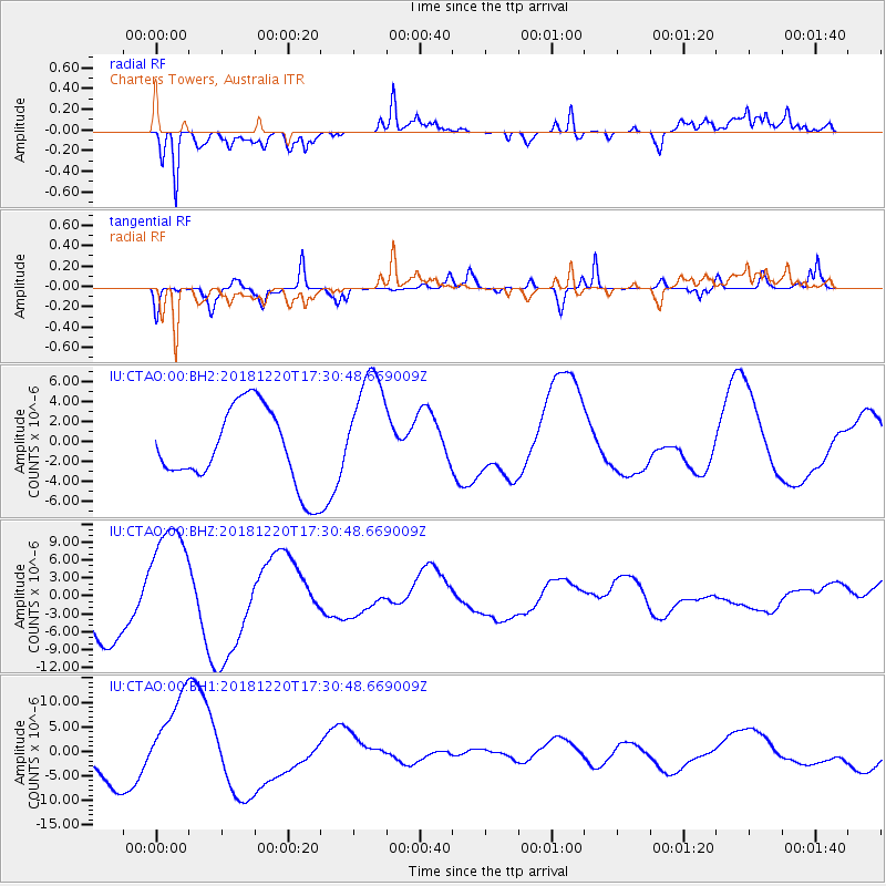
CTAO Charters Towers, Australia - Earthquake Result Viewer
*The percent match for this event was below the threshold and hence no stack was calculated.
| Earthquake location: |
Komandorskiye Ostrova Region |
| Earthquake latitude/longitude: |
55.1/164.9 |
| Earthquake time(UTC): |
2018/12/20 (354) 17:19:29 GMT |
| Earthquake Depth: |
10 km |
| Earthquake Magnitude: |
5.6 mb |
| Earthquake Catalog/Contributor: |
NEIC PDE/us |
|
| Network: |
IU Global Seismograph Network (GSN - IRIS/USGS) |
| Station: |
CTAO Charters Towers, Australia |
| Lat/Lon: |
20.09 S/146.25 E |
| Elevation: |
357 m |
|
| Distance: |
76.5 deg |
| Az: |
197.968 deg |
| Baz: |
10.881 deg |
| Ray Param: |
$rayparam |
*The percent match for this event was below the threshold and hence was not used in the summary stack. |
|
| Radial Match: |
52.356606 % |
| Radial Bump: |
400 |
| Transverse Match: |
56.664406 % |
| Transverse Bump: |
322 |
| SOD ConfigId: |
3201911 |
| Insert Time: |
2019-01-03 17:23:33.585 +0000 |
| GWidth: |
2.5 |
| Max Bumps: |
400 |
| Tol: |
0.001 |
|
Signal To Noise
| Channel | StoN | STA | LTA |
| IU:CTAO:00:BHZ:20181220T17:30:48.669009Z | 2.2270844 | 1.0323662E-5 | 4.6355053E-6 |
| IU:CTAO:00:BH1:20181220T17:30:48.669009Z | 2.9973288 | 9.200306E-6 | 3.0695019E-6 |
| IU:CTAO:00:BH2:20181220T17:30:48.669009Z | 1.5587412 | 5.9935446E-6 | 3.8451185E-6 |
| Arrivals |
| Ps | |
| PpPs | |
| PsPs/PpSs | |


