You are here: Home > Network List > IU - Global Seismograph Network (GSN - IRIS/USGS) Stations List
> Station RSSD Black Hills, South Dakota, USA > Earthquake Result Viewer
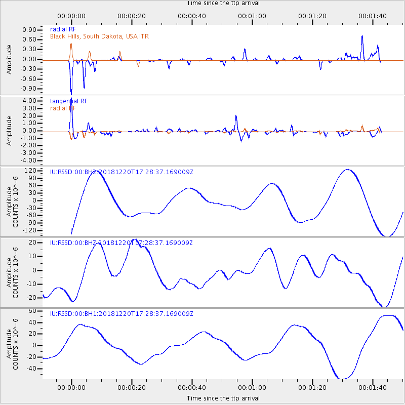
RSSD Black Hills, South Dakota, USA - Earthquake Result Viewer
*The percent match for this event was below the threshold and hence no stack was calculated.
| Earthquake location: |
Komandorskiye Ostrova Region |
| Earthquake latitude/longitude: |
55.1/164.9 |
| Earthquake time(UTC): |
2018/12/20 (354) 17:19:29 GMT |
| Earthquake Depth: |
10 km |
| Earthquake Magnitude: |
5.6 mb |
| Earthquake Catalog/Contributor: |
NEIC PDE/us |
|
| Network: |
IU Global Seismograph Network (GSN - IRIS/USGS) |
| Station: |
RSSD Black Hills, South Dakota, USA |
| Lat/Lon: |
44.12 N/104.04 W |
| Elevation: |
2090 m |
|
| Distance: |
56.0 deg |
| Az: |
60.324 deg |
| Baz: |
316.061 deg |
| Ray Param: |
$rayparam |
*The percent match for this event was below the threshold and hence was not used in the summary stack. |
|
| Radial Match: |
82.52554 % |
| Radial Bump: |
220 |
| Transverse Match: |
32.894405 % |
| Transverse Bump: |
273 |
| SOD ConfigId: |
3201911 |
| Insert Time: |
2019-01-03 17:23:48.399 +0000 |
| GWidth: |
2.5 |
| Max Bumps: |
400 |
| Tol: |
0.001 |
|
Signal To Noise
| Channel | StoN | STA | LTA |
| IU:RSSD:00:BHZ:20181220T17:28:37.169009Z | 1.3780286 | 1.698666E-5 | 1.2326783E-5 |
| IU:RSSD:00:BH1:20181220T17:28:37.169009Z | 3.16674 | 3.8746723E-5 | 1.2235523E-5 |
| IU:RSSD:00:BH2:20181220T17:28:37.169009Z | 0.44866407 | 3.172067E-5 | 7.070027E-5 |
| Arrivals |
| Ps | |
| PpPs | |
| PsPs/PpSs | |


