You are here: Home > Network List > CI - Caltech Regional Seismic Network Stations List
> Station BEL Belle Mtn, Joshua Tree National Park, CA, USA > Earthquake Result Viewer
BEL Belle Mtn, Joshua Tree National Park, CA, USA - Earthquake Result Viewer
| Earthquake location: |
Northern Chile |
| Earthquake latitude/longitude: |
-22.1/-68.2 |
| Earthquake time(UTC): |
2010/07/12 (193) 00:11:21 GMT |
| Earthquake Depth: |
115 km |
| Earthquake Magnitude: |
6.1 MB, 6.3 MW, 6.2 MW |
| Earthquake Catalog/Contributor: |
WHDF/NEIC |
|
| Network: |
CI Caltech Regional Seismic Network |
| Station: |
BEL Belle Mtn, Joshua Tree National Park, CA, USA |
| Lat/Lon: |
34.00 N/116.00 W |
| Elevation: |
1388 m |
|
| Distance: |
72.0 deg |
| Az: |
319.691 deg |
| Baz: |
133.787 deg |
| Ray Param: |
0.053658936 |
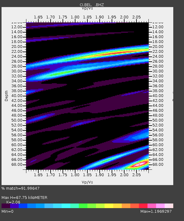
| Estimated Moho Depth: |
67.75 km |
| Estimated Crust Vp/Vs: |
2.06 |
| Assumed Crust Vp: |
6.276 km/s |
| Estimated Crust Vs: |
3.047 km/s |
| Estimated Crust Poisson's Ratio: |
0.35 |
|
| Radial Match: |
91.99647 % |
| Radial Bump: |
400 |
| Transverse Match: |
83.422295 % |
| Transverse Bump: |
400 |
| SOD ConfigId: |
319893 |
| Insert Time: |
2011-01-05 02:02:58.498 +0000 |
| GWidth: |
2.5 |
| Max Bumps: |
400 |
| Tol: |
0.001 |
|
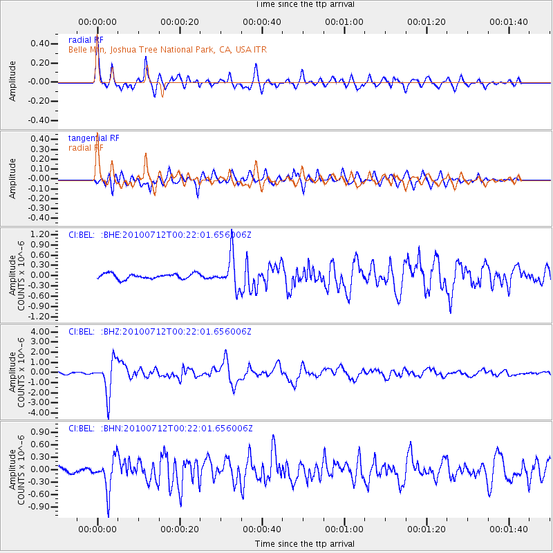
Signal To Noise
| Channel | StoN | STA | LTA |
| CI:BEL: :BHZ:20100712T00:22:01.656006Z | 18.812897 | 1.7279372E-6 | 9.184854E-8 |
| CI:BEL: :BHN:20100712T00:22:01.656006Z | 5.1215878 | 4.0782348E-7 | 7.962833E-8 |
| CI:BEL: :BHE:20100712T00:22:01.656006Z | 6.5183325 | 4.9870414E-7 | 7.650794E-8 |
| Arrivals |
| Ps | 12 SECOND |
| PpPs | 32 SECOND |
| PsPs/PpSs | 44 SECOND |


