You are here: Home > Network List > IW - Intermountain West Stations List
> Station MOOW Moose Ponds, Wyoming, USA > Earthquake Result Viewer
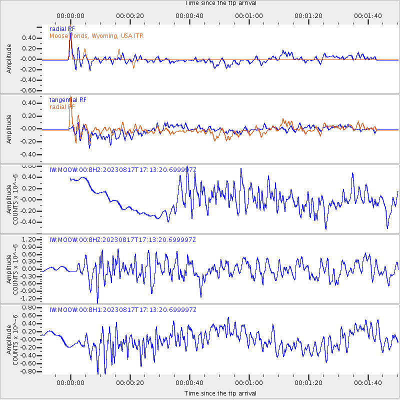
MOOW Moose Ponds, Wyoming, USA - Earthquake Result Viewer
*The percent match for this event was below the threshold and hence no stack was calculated.
| Earthquake location: |
Colombia |
| Earthquake latitude/longitude: |
4.4/-73.6 |
| Earthquake time(UTC): |
2023/08/17 (229) 17:04:48 GMT |
| Earthquake Depth: |
10 km |
| Earthquake Magnitude: |
6.2 mww |
| Earthquake Catalog/Contributor: |
NEIC PDE/us |
|
| Network: |
IW Intermountain West |
| Station: |
MOOW Moose Ponds, Wyoming, USA |
| Lat/Lon: |
43.75 N/110.74 W |
| Elevation: |
2128 m |
|
| Distance: |
51.1 deg |
| Az: |
325.757 deg |
| Baz: |
129.263 deg |
| Ray Param: |
$rayparam |
*The percent match for this event was below the threshold and hence was not used in the summary stack. |
|
| Radial Match: |
47.495487 % |
| Radial Bump: |
400 |
| Transverse Match: |
50.843727 % |
| Transverse Bump: |
400 |
| SOD ConfigId: |
31937991 |
| Insert Time: |
2023-08-31 17:19:08.125 +0000 |
| GWidth: |
2.5 |
| Max Bumps: |
400 |
| Tol: |
0.001 |
|
Signal To Noise
| Channel | StoN | STA | LTA |
| IW:MOOW:00:BHZ:20230817T17:13:20.699997Z | 1.5816311 | 1.2496491E-7 | 7.901016E-8 |
| IW:MOOW:00:BH1:20230817T17:13:20.699997Z | 1.3202999 | 2.0758505E-7 | 1.5722568E-7 |
| IW:MOOW:00:BH2:20230817T17:13:20.699997Z | 1.5263871 | 3.2984613E-7 | 2.16096E-7 |
| Arrivals |
| Ps | |
| PpPs | |
| PsPs/PpSs | |


