You are here: Home > Network List > N4 - Central and EAstern US Network Stations List
> Station Q44B Vandalia, IL, USA > Earthquake Result Viewer
Q44B Vandalia, IL, USA - Earthquake Result Viewer
| Earthquake location: |
Colombia |
| Earthquake latitude/longitude: |
4.4/-73.6 |
| Earthquake time(UTC): |
2023/08/17 (229) 17:04:48 GMT |
| Earthquake Depth: |
10 km |
| Earthquake Magnitude: |
6.2 mww |
| Earthquake Catalog/Contributor: |
NEIC PDE/us |
|
| Network: |
N4 Central and EAstern US Network |
| Station: |
Q44B Vandalia, IL, USA |
| Lat/Lon: |
38.90 N/89.02 W |
| Elevation: |
168 m |
|
| Distance: |
37.1 deg |
| Az: |
339.853 deg |
| Baz: |
153.885 deg |
| Ray Param: |
0.07631853 |
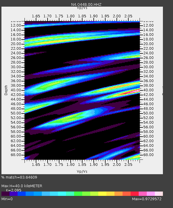
| Estimated Moho Depth: |
40.0 km |
| Estimated Crust Vp/Vs: |
2.10 |
| Assumed Crust Vp: |
6.444 km/s |
| Estimated Crust Vs: |
3.076 km/s |
| Estimated Crust Poisson's Ratio: |
0.35 |
|
| Radial Match: |
83.64609 % |
| Radial Bump: |
400 |
| Transverse Match: |
61.919678 % |
| Transverse Bump: |
400 |
| SOD ConfigId: |
31937991 |
| Insert Time: |
2023-08-31 17:20:55.775 +0000 |
| GWidth: |
2.5 |
| Max Bumps: |
400 |
| Tol: |
0.001 |
|

Signal To Noise
| Channel | StoN | STA | LTA |
| N4:Q44B:00:HHZ:20230817T17:11:28.879989Z | 1.5827239 | 2.0492084E-7 | 1.2947353E-7 |
| N4:Q44B:00:HH1:20230817T17:11:28.879989Z | 2.2716854 | 3.1769247E-7 | 1.3984881E-7 |
| N4:Q44B:00:HH2:20230817T17:11:28.879989Z | 0.734819 | 1.4408756E-7 | 1.960858E-7 |
| Arrivals |
| Ps | 7.2 SECOND |
| PpPs | 18 SECOND |
| PsPs/PpSs | 25 SECOND |


