You are here: Home > Network List > NM - Cooperative New Madrid Seismic Network Stations List
> Station MGMO Mountain Grove, MO > Earthquake Result Viewer
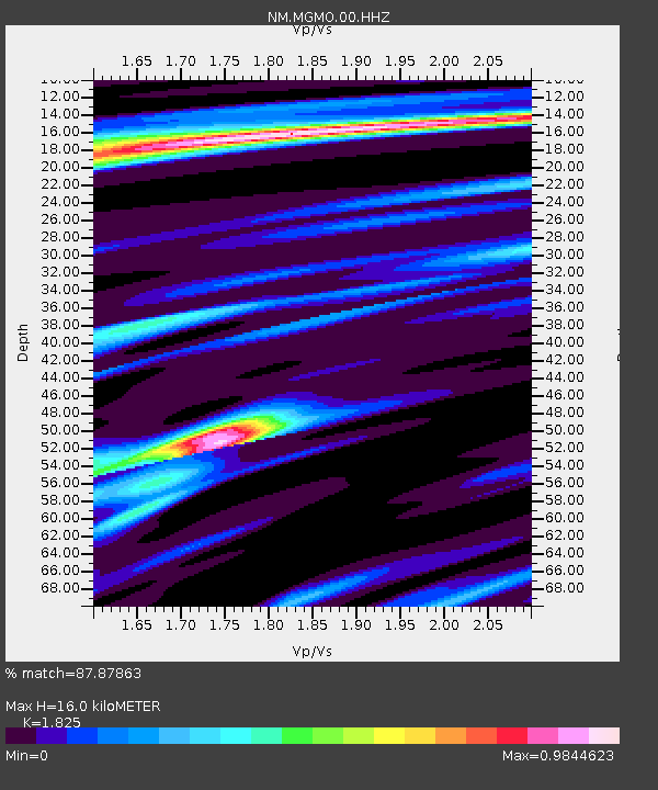
MGMO Mountain Grove, MO - Earthquake Result Viewer
| Earthquake location: |
Colombia |
| Earthquake latitude/longitude: |
4.4/-73.6 |
| Earthquake time(UTC): |
2023/08/17 (229) 17:04:48 GMT |
| Earthquake Depth: |
10 km |
| Earthquake Magnitude: |
6.2 mww |
| Earthquake Catalog/Contributor: |
NEIC PDE/us |
|
| Network: |
NM Cooperative New Madrid Seismic Network |
| Station: |
MGMO Mountain Grove, MO |
| Lat/Lon: |
37.15 N/92.27 W |
| Elevation: |
453 m |
|
| Distance: |
36.9 deg |
| Az: |
334.712 deg |
| Baz: |
147.784 deg |
| Ray Param: |
0.07647482 |
| Estimated Moho Depth: |
16.0 km |
| Estimated Crust Vp/Vs: |
1.83 |
| Assumed Crust Vp: |
6.53 km/s |
| Estimated Crust Vs: |
3.578 km/s |
| Estimated Crust Poisson's Ratio: |
0.29 |
|
| Radial Match: |
87.87863 % |
| Radial Bump: |
251 |
| Transverse Match: |
69.57213 % |
| Transverse Bump: |
400 |
| SOD ConfigId: |
31937991 |
| Insert Time: |
2023-08-31 17:22:07.058 +0000 |
| GWidth: |
2.5 |
| Max Bumps: |
400 |
| Tol: |
0.001 |
|

Signal To Noise
| Channel | StoN | STA | LTA |
| NM:MGMO:00:HHZ:20230817T17:11:26.560012Z | 2.7293324 | 2.6751397E-7 | 9.8014425E-8 |
| NM:MGMO:00:HHN:20230817T17:11:26.560012Z | 2.0709794 | 1.6304638E-7 | 7.872912E-8 |
| NM:MGMO:00:HHE:20230817T17:11:26.560012Z | 1.0053662 | 8.745149E-8 | 8.698471E-8 |
| Arrivals |
| Ps | 2.2 SECOND |
| PpPs | 6.4 SECOND |
| PsPs/PpSs | 8.6 SECOND |


