You are here: Home > Network List > IW - Intermountain West Stations List
> Station IMW Indian Meadow, Wyoming, USA > Earthquake Result Viewer
IMW Indian Meadow, Wyoming, USA - Earthquake Result Viewer
| Earthquake location: |
Northern Chile |
| Earthquake latitude/longitude: |
-22.1/-68.2 |
| Earthquake time(UTC): |
2010/07/12 (193) 00:11:21 GMT |
| Earthquake Depth: |
115 km |
| Earthquake Magnitude: |
6.1 MB, 6.3 MW, 6.2 MW |
| Earthquake Catalog/Contributor: |
WHDF/NEIC |
|
| Network: |
IW Intermountain West |
| Station: |
IMW Indian Meadow, Wyoming, USA |
| Lat/Lon: |
43.90 N/110.94 W |
| Elevation: |
2646 m |
|
| Distance: |
76.5 deg |
| Az: |
329.709 deg |
| Baz: |
139.694 deg |
| Ray Param: |
0.05067876 |
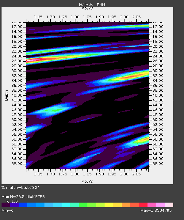
| Estimated Moho Depth: |
25.5 km |
| Estimated Crust Vp/Vs: |
1.60 |
| Assumed Crust Vp: |
6.207 km/s |
| Estimated Crust Vs: |
3.879 km/s |
| Estimated Crust Poisson's Ratio: |
0.18 |
|
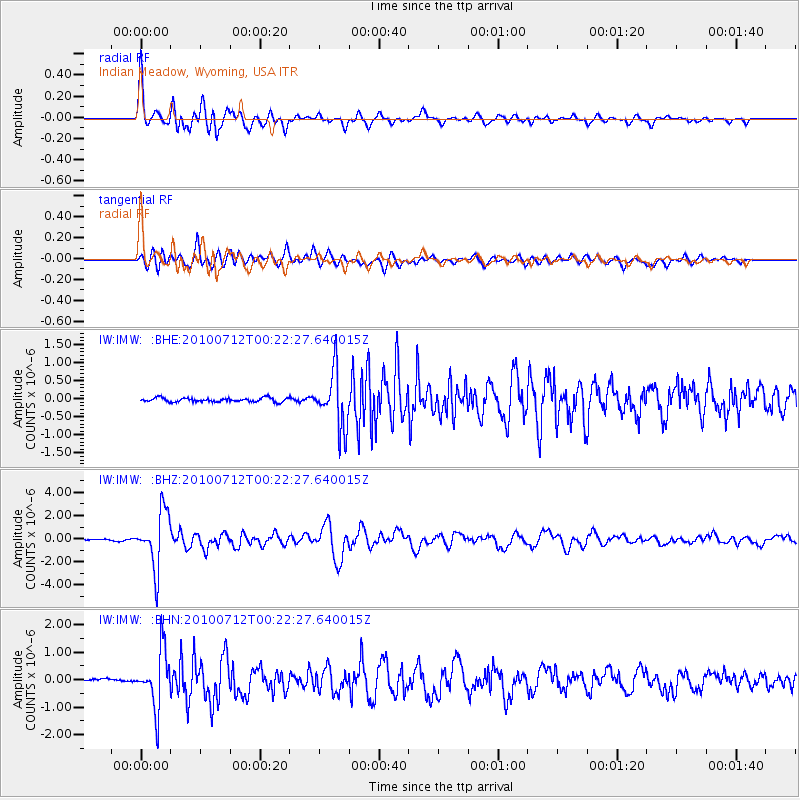
| Radial Match: |
95.97304 % |
| Radial Bump: |
400 |
| Transverse Match: |
91.32879 % |
| Transverse Bump: |
400 |
| SOD ConfigId: |
319893 |
| Insert Time: |
2011-01-05 02:06:59.710 +0000 |
| GWidth: |
2.5 |
| Max Bumps: |
400 |
| Tol: |
0.001 |
|
Signal To Noise
| Channel | StoN | STA | LTA |
| IW:IMW: :BHZ:20100712T00:22:27.640015Z | 58.2667 | 2.4256115E-6 | 4.1629463E-8 |
| IW:IMW: :BHN:20100712T00:22:27.640015Z | 21.540884 | 1.0459958E-6 | 4.855863E-8 |
| IW:IMW: :BHE:20100712T00:22:27.640015Z | 14.253158 | 7.803305E-7 | 5.4747904E-8 |
| Arrivals |
| Ps | 2.5 SECOND |
| PpPs | 10 SECOND |
| PsPs/PpSs | 13 SECOND |


