You are here: Home > Network List > O2 - Oklahoma Consolidated Temporary Seismic Networks Stations List
> Station SC18 Garber, Oklahoma, USA > Earthquake Result Viewer
SC18 Garber, Oklahoma, USA - Earthquake Result Viewer
| Earthquake location: |
Colombia |
| Earthquake latitude/longitude: |
4.4/-73.6 |
| Earthquake time(UTC): |
2023/08/17 (229) 17:04:48 GMT |
| Earthquake Depth: |
10 km |
| Earthquake Magnitude: |
6.2 mww |
| Earthquake Catalog/Contributor: |
NEIC PDE/us |
|
| Network: |
O2 Oklahoma Consolidated Temporary Seismic Networks |
| Station: |
SC18 Garber, Oklahoma, USA |
| Lat/Lon: |
36.50 N/97.55 W |
| Elevation: |
1051 m |
|
| Distance: |
38.9 deg |
| Az: |
328.512 deg |
| Baz: |
139.73 deg |
| Ray Param: |
0.07535047 |
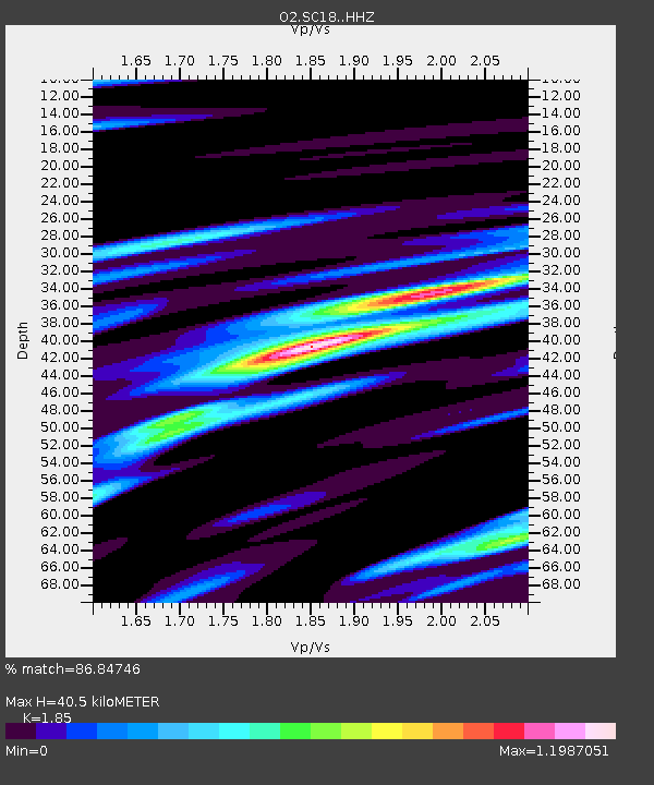
| Estimated Moho Depth: |
40.5 km |
| Estimated Crust Vp/Vs: |
1.85 |
| Assumed Crust Vp: |
6.483 km/s |
| Estimated Crust Vs: |
3.504 km/s |
| Estimated Crust Poisson's Ratio: |
0.29 |
|
| Radial Match: |
86.84746 % |
| Radial Bump: |
346 |
| Transverse Match: |
56.437946 % |
| Transverse Bump: |
400 |
| SOD ConfigId: |
31937991 |
| Insert Time: |
2023-08-31 17:24:11.055 +0000 |
| GWidth: |
2.5 |
| Max Bumps: |
400 |
| Tol: |
0.001 |
|

Signal To Noise
| Channel | StoN | STA | LTA |
| O2:SC18: :HHZ:20230817T17:11:43.305008Z | 2.8011005 | 3.4013965E-7 | 1.2143072E-7 |
| O2:SC18: :HHN:20230817T17:11:43.305008Z | 1.4498966 | 1.89677E-7 | 1.3082105E-7 |
| O2:SC18: :HHE:20230817T17:11:43.305008Z | 1.4979867 | 1.8809975E-7 | 1.2556836E-7 |
| Arrivals |
| Ps | 5.7 SECOND |
| PpPs | 17 SECOND |
| PsPs/PpSs | 22 SECOND |


