You are here: Home > Network List > IW - Intermountain West Stations List
> Station DLMT Dillon, Montana, USA > Earthquake Result Viewer
DLMT Dillon, Montana, USA - Earthquake Result Viewer
| Earthquake location: |
Northern Chile |
| Earthquake latitude/longitude: |
-22.1/-68.2 |
| Earthquake time(UTC): |
2010/07/12 (193) 00:11:21 GMT |
| Earthquake Depth: |
115 km |
| Earthquake Magnitude: |
6.1 MB, 6.3 MW, 6.2 MW |
| Earthquake Catalog/Contributor: |
WHDF/NEIC |
|
| Network: |
IW Intermountain West |
| Station: |
DLMT Dillon, Montana, USA |
| Lat/Lon: |
45.36 N/112.60 W |
| Elevation: |
1569 m |
|
| Distance: |
78.4 deg |
| Az: |
329.775 deg |
| Baz: |
138.548 deg |
| Ray Param: |
0.049410876 |
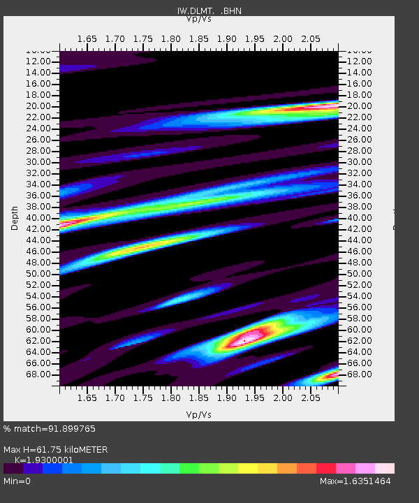
| Estimated Moho Depth: |
61.75 km |
| Estimated Crust Vp/Vs: |
1.93 |
| Assumed Crust Vp: |
6.577 km/s |
| Estimated Crust Vs: |
3.408 km/s |
| Estimated Crust Poisson's Ratio: |
0.32 |
|
| Radial Match: |
91.899765 % |
| Radial Bump: |
400 |
| Transverse Match: |
84.22307 % |
| Transverse Bump: |
400 |
| SOD ConfigId: |
319893 |
| Insert Time: |
2011-01-05 02:07:23.840 +0000 |
| GWidth: |
2.5 |
| Max Bumps: |
400 |
| Tol: |
0.001 |
|
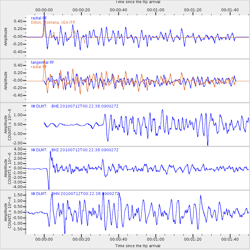
Signal To Noise
| Channel | StoN | STA | LTA |
| IW:DLMT: :BHZ:20100712T00:22:38.090027Z | 62.79392 | 1.8808564E-6 | 2.9952844E-8 |
| IW:DLMT: :BHN:20100712T00:22:38.090027Z | 9.404001 | 7.294045E-7 | 7.756321E-8 |
| IW:DLMT: :BHE:20100712T00:22:38.090027Z | 7.598863 | 7.6079306E-7 | 1.0011932E-7 |
| Arrivals |
| Ps | 9.0 SECOND |
| PpPs | 27 SECOND |
| PsPs/PpSs | 36 SECOND |


