You are here: Home > Network List > IW - Intermountain West Stations List
> Station MFID Camas Ranch, Mayfield, ID, USA > Earthquake Result Viewer
MFID Camas Ranch, Mayfield, ID, USA - Earthquake Result Viewer
| Earthquake location: |
Northern Chile |
| Earthquake latitude/longitude: |
-22.1/-68.2 |
| Earthquake time(UTC): |
2010/07/12 (193) 00:11:21 GMT |
| Earthquake Depth: |
115 km |
| Earthquake Magnitude: |
6.1 MB, 6.3 MW, 6.2 MW |
| Earthquake Catalog/Contributor: |
WHDF/NEIC |
|
| Network: |
IW Intermountain West |
| Station: |
MFID Camas Ranch, Mayfield, ID, USA |
| Lat/Lon: |
43.42 N/115.83 W |
| Elevation: |
1302 m |
|
| Distance: |
78.5 deg |
| Az: |
326.69 deg |
| Baz: |
135.678 deg |
| Ray Param: |
0.049309764 |
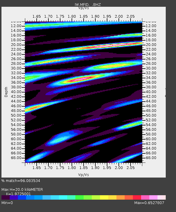
| Estimated Moho Depth: |
20.0 km |
| Estimated Crust Vp/Vs: |
1.97 |
| Assumed Crust Vp: |
6.291 km/s |
| Estimated Crust Vs: |
3.189 km/s |
| Estimated Crust Poisson's Ratio: |
0.33 |
|
| Radial Match: |
96.083534 % |
| Radial Bump: |
400 |
| Transverse Match: |
84.85581 % |
| Transverse Bump: |
400 |
| SOD ConfigId: |
319893 |
| Insert Time: |
2011-01-05 02:07:35.993 +0000 |
| GWidth: |
2.5 |
| Max Bumps: |
400 |
| Tol: |
0.001 |
|

Signal To Noise
| Channel | StoN | STA | LTA |
| IW:MFID: :BHZ:20100712T00:22:38.900024Z | 46.14241 | 2.9909172E-6 | 6.481927E-8 |
| IW:MFID: :BHN:20100712T00:22:38.900024Z | 13.928256 | 8.2485224E-7 | 5.9221502E-8 |
| IW:MFID: :BHE:20100712T00:22:38.900024Z | 10.018706 | 6.7221004E-7 | 6.709549E-8 |
| Arrivals |
| Ps | 3.2 SECOND |
| PpPs | 9.2 SECOND |
| PsPs/PpSs | 12 SECOND |


