You are here: Home > Network List > US - United States National Seismic Network Stations List
> Station WMOK Wichita Mountains, Oklahoma, USA > Earthquake Result Viewer
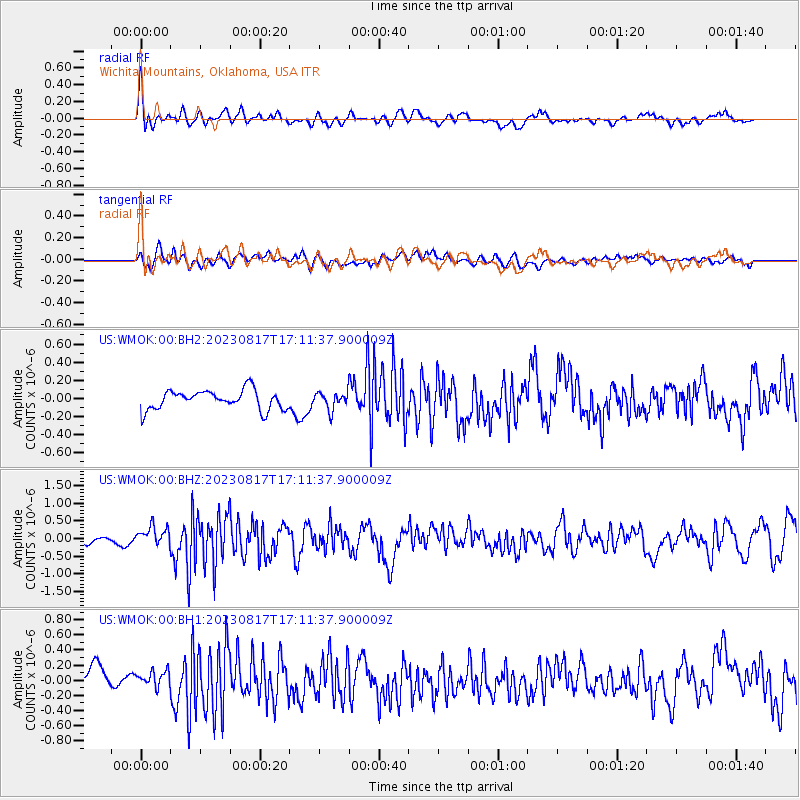
WMOK Wichita Mountains, Oklahoma, USA - Earthquake Result Viewer
*The percent match for this event was below the threshold and hence no stack was calculated.
| Earthquake location: |
Colombia |
| Earthquake latitude/longitude: |
4.4/-73.6 |
| Earthquake time(UTC): |
2023/08/17 (229) 17:04:48 GMT |
| Earthquake Depth: |
10 km |
| Earthquake Magnitude: |
6.2 mww |
| Earthquake Catalog/Contributor: |
NEIC PDE/us |
|
| Network: |
US United States National Seismic Network |
| Station: |
WMOK Wichita Mountains, Oklahoma, USA |
| Lat/Lon: |
34.74 N/98.78 W |
| Elevation: |
486 m |
|
| Distance: |
38.2 deg |
| Az: |
325.431 deg |
| Baz: |
136.608 deg |
| Ray Param: |
$rayparam |
*The percent match for this event was below the threshold and hence was not used in the summary stack. |
|
| Radial Match: |
75.59826 % |
| Radial Bump: |
400 |
| Transverse Match: |
63.840767 % |
| Transverse Bump: |
400 |
| SOD ConfigId: |
31937991 |
| Insert Time: |
2023-08-31 17:30:22.611 +0000 |
| GWidth: |
2.5 |
| Max Bumps: |
400 |
| Tol: |
0.001 |
|
Signal To Noise
| Channel | StoN | STA | LTA |
| US:WMOK:00:BHZ:20230817T17:11:37.900009Z | 2.7798266 | 2.7620857E-7 | 9.93618E-8 |
| US:WMOK:00:BH1:20230817T17:11:37.900009Z | 0.76327354 | 9.745665E-8 | 1.2768247E-7 |
| US:WMOK:00:BH2:20230817T17:11:37.900009Z | 0.87559164 | 9.3606914E-8 | 1.0690704E-7 |
| Arrivals |
| Ps | |
| PpPs | |
| PsPs/PpSs | |


