You are here: Home > Network List > YX16 - Raton Basin UNM Broadband Network Stations List
> Station UNM2 SE Corner of NM Stations > Earthquake Result Viewer
UNM2 SE Corner of NM Stations - Earthquake Result Viewer
| Earthquake location: |
Colombia |
| Earthquake latitude/longitude: |
4.4/-73.6 |
| Earthquake time(UTC): |
2023/08/17 (229) 17:04:48 GMT |
| Earthquake Depth: |
10 km |
| Earthquake Magnitude: |
6.2 mww |
| Earthquake Catalog/Contributor: |
NEIC PDE/us |
|
| Network: |
YX Raton Basin UNM Broadband Network |
| Station: |
UNM2 SE Corner of NM Stations |
| Lat/Lon: |
36.80 N/104.86 W |
| Elevation: |
2166 m |
|
| Distance: |
43.2 deg |
| Az: |
322.471 deg |
| Baz: |
130.819 deg |
| Ray Param: |
0.072705224 |
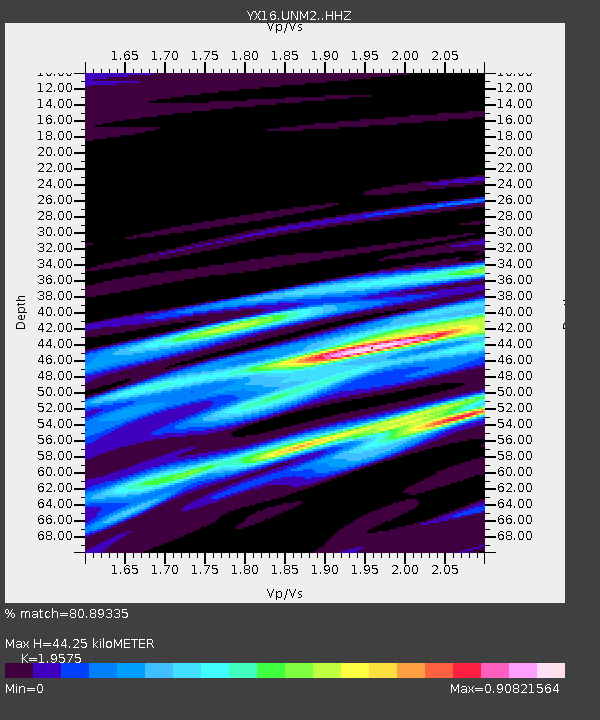
| Estimated Moho Depth: |
44.25 km |
| Estimated Crust Vp/Vs: |
1.96 |
| Assumed Crust Vp: |
6.316 km/s |
| Estimated Crust Vs: |
3.226 km/s |
| Estimated Crust Poisson's Ratio: |
0.32 |
|
| Radial Match: |
80.89335 % |
| Radial Bump: |
400 |
| Transverse Match: |
71.57465 % |
| Transverse Bump: |
400 |
| SOD ConfigId: |
31937991 |
| Insert Time: |
2023-08-31 17:32:58.590 +0000 |
| GWidth: |
2.5 |
| Max Bumps: |
400 |
| Tol: |
0.001 |
|

Signal To Noise
| Channel | StoN | STA | LTA |
| YX:UNM2: :HHZ:20230817T17:12:19.09999Z | 2.7233856 | 2.1435767E-7 | 7.8709995E-8 |
| YX:UNM2: :HHN:20230817T17:12:19.09999Z | 1.3626401 | 1.4295738E-7 | 1.04912054E-7 |
| YX:UNM2: :HHE:20230817T17:12:19.09999Z | 1.231257 | 1.364759E-7 | 1.1084275E-7 |
| Arrivals |
| Ps | 7.1 SECOND |
| PpPs | 20 SECOND |
| PsPs/PpSs | 27 SECOND |


