You are here: Home > Network List > US - United States National Seismic Network Stations List
> Station TPNV Topopah Spring, Nevada, USA > Earthquake Result Viewer
TPNV Topopah Spring, Nevada, USA - Earthquake Result Viewer
| Earthquake location: |
Komandorskiye Ostrova Region |
| Earthquake latitude/longitude: |
55.1/164.9 |
| Earthquake time(UTC): |
2018/12/20 (354) 17:19:29 GMT |
| Earthquake Depth: |
10 km |
| Earthquake Magnitude: |
5.6 mb |
| Earthquake Catalog/Contributor: |
NEIC PDE/us |
|
| Network: |
US United States National Seismic Network |
| Station: |
TPNV Topopah Spring, Nevada, USA |
| Lat/Lon: |
36.95 N/116.25 W |
| Elevation: |
1600 m |
|
| Distance: |
54.7 deg |
| Az: |
74.506 deg |
| Baz: |
316.22 deg |
| Ray Param: |
0.065310225 |
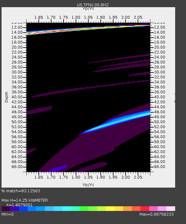
| Estimated Moho Depth: |
14.25 km |
| Estimated Crust Vp/Vs: |
1.61 |
| Assumed Crust Vp: |
6.279 km/s |
| Estimated Crust Vs: |
3.906 km/s |
| Estimated Crust Poisson's Ratio: |
0.18 |
|
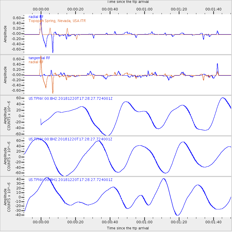
| Radial Match: |
93.12583 % |
| Radial Bump: |
360 |
| Transverse Match: |
65.46037 % |
| Transverse Bump: |
400 |
| SOD ConfigId: |
3201911 |
| Insert Time: |
2019-01-03 17:26:41.214 +0000 |
| GWidth: |
2.5 |
| Max Bumps: |
400 |
| Tol: |
0.001 |
|
Signal To Noise
| Channel | StoN | STA | LTA |
| US:TPNV:00:BHZ:20181220T17:28:27.724001Z | 2.6862378 | 6.97264E-5 | 2.5956897E-5 |
| US:TPNV:00:BH1:20181220T17:28:27.724001Z | 1.6007305 | 4.6847494E-5 | 2.9266323E-5 |
| US:TPNV:00:BH2:20181220T17:28:27.724001Z | 2.652356 | 4.3604312E-5 | 1.6439843E-5 |
| Arrivals |
| Ps | 1.5 SECOND |
| PpPs | 5.6 SECOND |
| PsPs/PpSs | 7.1 SECOND |


