You are here: Home > Network List > GS - US Geological Survey Networks Stations List
> Station DEC04 Decatur Surface Seismic Site, Decatur, IL, USA > Earthquake Result Viewer
DEC04 Decatur Surface Seismic Site, Decatur, IL, USA - Earthquake Result Viewer
| Earthquake location: |
Colombia |
| Earthquake latitude/longitude: |
4.2/-73.6 |
| Earthquake time(UTC): |
2023/08/17 (229) 17:17:18 GMT |
| Earthquake Depth: |
7.9 km |
| Earthquake Magnitude: |
5.7 Mww |
| Earthquake Catalog/Contributor: |
NEIC PDE/us |
|
| Network: |
GS US Geological Survey Networks |
| Station: |
DEC04 Decatur Surface Seismic Site, Decatur, IL, USA |
| Lat/Lon: |
39.88 N/88.86 W |
| Elevation: |
225 m |
|
| Distance: |
38.1 deg |
| Az: |
340.842 deg |
| Baz: |
154.829 deg |
| Ray Param: |
0.07577495 |
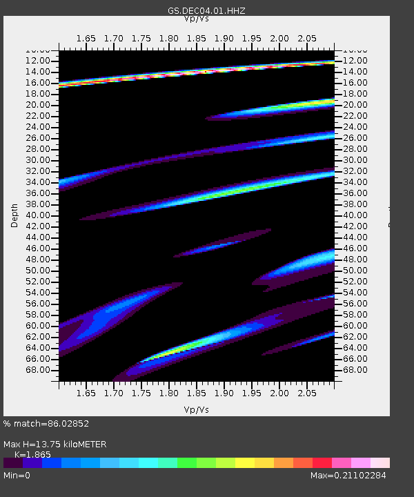
| Estimated Moho Depth: |
13.75 km |
| Estimated Crust Vp/Vs: |
1.87 |
| Assumed Crust Vp: |
6.444 km/s |
| Estimated Crust Vs: |
3.455 km/s |
| Estimated Crust Poisson's Ratio: |
0.30 |
|
| Radial Match: |
86.02852 % |
| Radial Bump: |
290 |
| Transverse Match: |
38.669044 % |
| Transverse Bump: |
372 |
| SOD ConfigId: |
31937991 |
| Insert Time: |
2023-08-31 17:44:22.432 +0000 |
| GWidth: |
2.5 |
| Max Bumps: |
400 |
| Tol: |
0.001 |
|

Signal To Noise
| Channel | StoN | STA | LTA |
| GS:DEC04:01:HHZ:20230817T17:24:06.33999Z | 2.057147 | 1.8802374E-6 | 9.1400244E-7 |
| GS:DEC04:01:HHN:20230817T17:24:06.33999Z | 0.31882986 | 6.987804E-7 | 2.191703E-6 |
| GS:DEC04:01:HHE:20230817T17:24:06.33999Z | 1.5292633 | 3.4795532E-6 | 2.2753134E-6 |
| Arrivals |
| Ps | 2.0 SECOND |
| PpPs | 5.7 SECOND |
| PsPs/PpSs | 7.7 SECOND |


