You are here: Home > Network List > GS - US Geological Survey Networks Stations List
> Station OK052 Battle Ridge Rd, NW of Cushing, Oklahoma USA > Earthquake Result Viewer
OK052 Battle Ridge Rd, NW of Cushing, Oklahoma USA - Earthquake Result Viewer
| Earthquake location: |
Colombia |
| Earthquake latitude/longitude: |
4.2/-73.6 |
| Earthquake time(UTC): |
2023/08/17 (229) 17:17:18 GMT |
| Earthquake Depth: |
7.9 km |
| Earthquake Magnitude: |
5.7 Mww |
| Earthquake Catalog/Contributor: |
NEIC PDE/us |
|
| Network: |
GS US Geological Survey Networks |
| Station: |
OK052 Battle Ridge Rd, NW of Cushing, Oklahoma USA |
| Lat/Lon: |
36.00 N/96.80 W |
| Elevation: |
261 m |
|
| Distance: |
38.2 deg |
| Az: |
328.885 deg |
| Baz: |
140.54 deg |
| Ray Param: |
0.07573438 |
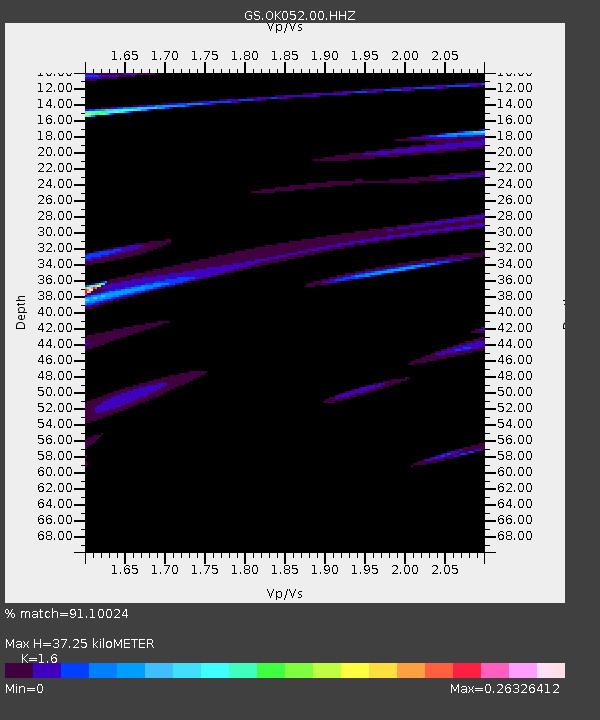
| Estimated Moho Depth: |
37.25 km |
| Estimated Crust Vp/Vs: |
1.60 |
| Assumed Crust Vp: |
6.426 km/s |
| Estimated Crust Vs: |
4.016 km/s |
| Estimated Crust Poisson's Ratio: |
0.18 |
|
| Radial Match: |
91.10024 % |
| Radial Bump: |
400 |
| Transverse Match: |
67.544426 % |
| Transverse Bump: |
400 |
| SOD ConfigId: |
31937991 |
| Insert Time: |
2023-08-31 17:44:30.092 +0000 |
| GWidth: |
2.5 |
| Max Bumps: |
400 |
| Tol: |
0.001 |
|

Signal To Noise
| Channel | StoN | STA | LTA |
| GS:OK052:00:HHZ:20230817T17:24:07.079004Z | 3.4680614 | 1.7281711E-6 | 4.983104E-7 |
| GS:OK052:00:HH1:20230817T17:24:07.079004Z | 0.73256207 | 4.0273625E-7 | 5.49764E-7 |
| GS:OK052:00:HH2:20230817T17:24:07.079004Z | 0.36412618 | 2.8330294E-7 | 7.7803503E-7 |
| Arrivals |
| Ps | 3.8 SECOND |
| PpPs | 14 SECOND |
| PsPs/PpSs | 18 SECOND |


