You are here: Home > Network List > TX - Texas Seismological Network Stations List
> Station ET01 Chireno > Earthquake Result Viewer
ET01 Chireno - Earthquake Result Viewer
| Earthquake location: |
Colombia |
| Earthquake latitude/longitude: |
4.2/-73.6 |
| Earthquake time(UTC): |
2023/08/17 (229) 17:17:18 GMT |
| Earthquake Depth: |
7.9 km |
| Earthquake Magnitude: |
5.7 Mww |
| Earthquake Catalog/Contributor: |
NEIC PDE/us |
|
| Network: |
TX Texas Seismological Network |
| Station: |
ET01 Chireno |
| Lat/Lon: |
31.46 N/94.37 W |
| Elevation: |
127 m |
|
| Distance: |
33.4 deg |
| Az: |
326.622 deg |
| Baz: |
140.051 deg |
| Ray Param: |
0.07824309 |
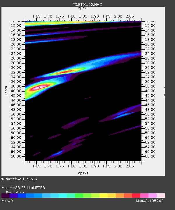
| Estimated Moho Depth: |
38.25 km |
| Estimated Crust Vp/Vs: |
1.66 |
| Assumed Crust Vp: |
5.738 km/s |
| Estimated Crust Vs: |
3.452 km/s |
| Estimated Crust Poisson's Ratio: |
0.22 |
|
| Radial Match: |
91.73514 % |
| Radial Bump: |
400 |
| Transverse Match: |
77.45471 % |
| Transverse Bump: |
400 |
| SOD ConfigId: |
31937991 |
| Insert Time: |
2023-08-31 17:53:22.856 +0000 |
| GWidth: |
2.5 |
| Max Bumps: |
400 |
| Tol: |
0.001 |
|

Signal To Noise
| Channel | StoN | STA | LTA |
| TX:ET01:00:HHZ:20230817T17:23:26.219995Z | 0.66025454 | 1.1456067E-6 | 1.7350986E-6 |
| TX:ET01:00:HH1:20230817T17:23:26.219995Z | 1.0664507 | 2.978792E-6 | 2.793183E-6 |
| TX:ET01:00:HH2:20230817T17:23:26.219995Z | 0.99937737 | 2.258551E-6 | 2.259958E-6 |
| Arrivals |
| Ps | 4.7 SECOND |
| PpPs | 17 SECOND |
| PsPs/PpSs | 21 SECOND |


